|
|
| Mesoscale Discussion 1345 | |
| < Previous MD | |

|
|
   Mesoscale Discussion 1345
   NWS Storm Prediction Center Norman OK
   0238 PM CDT Thu Jun 20 2024

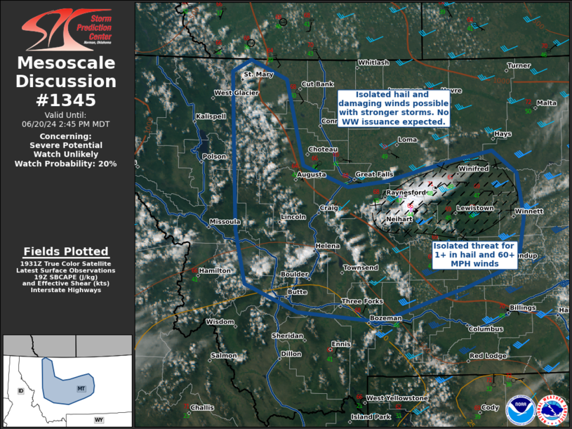
   Areas affected...West Central Montana

   Concerning...Severe potential...Watch unlikely

   Valid 201938Z - 202045Z

   Probability of Watch Issuance...20 percent

   SUMMARY...Thunderstorm development over the mountains has increased
   over the last half hour, with the potential for a supercell or two
   to develop in Central MT. Isolated hail and damaging winds are
   possible, especially with isolated convection that moves eastward
   into the better buoyancy and shear. WW issuance is not likely due to
   uncertainty in spatial coverage of severe threats.

   DISCUSSION...Thunderstorms are increasing in coverage along the
   mountains in far western MT, and a more mature thunderstorm has
   developed over Judith Basin county. Due to proximity to the upper
   trough, RAP forecast profiles show cold temperatures aloft
   supportive of SBCAPE > 1000 J/kg. Deep layer shear over Central and
   Eastern MT are in the range of 40-50kts, decreasing towards the west
   over the higher terrain.

   Any convection that tracks further east into Central MT should
   encounter better combinations of shear and buoyancy, resulting in an
   isolated threat for 1+ inch hail and 60+ MPH wind gusts.

   However, due to uncertainty in spatial coverage of organized severe
   storms, WW issuance is not expected at this time.

   ..Halbert/Lyons/Hart.. 06/20/2024

   ...Please see www.spc.noaa.gov for graphic product...

   ATTN...WFO...BYZ...GGW...TFX...MSO...

   LAT...LON   46841349 47991355 48831361 48991326 48751257 47661225
               47391140 47471071 47720948 47830872 47540826 46990815
               46520826 46310857 46120922 45960985 45681080 45801233
               46151329 46841349
|
|
|
Top/All Mesoscale Discussions/Forecast Products/Home |
|


