| Mesoscale Discussion 1336 | |
| < Previous MD Next MD > | |

|
|
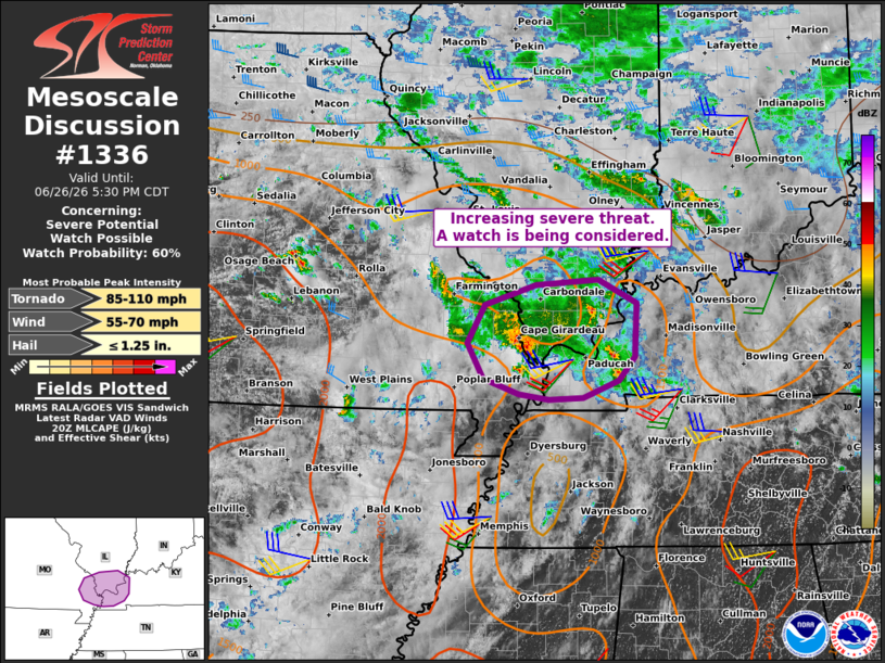
   Mesoscale Discussion 1336
   NWS Storm Prediction Center Norman OK
   0336 PM CDT Fri Jun 26 2026

   Areas affected...southeast Missouri into southern Illinois and
   western Kentucky

   Concerning...Severe potential...Watch possible

   Valid 262036Z - 262230Z

   Probability of Watch Issuance...60 percent

   SUMMARY...The potential for a few severe storms capable of locally
   damaging winds and perhaps a few tornadoes appears to be increasing.
   Convective trends are being monitored for a possible watch.

   DISCUSSION...A small cluster of thunderstorms has recently
   intensified in the vicinity of I-55 near Cape Girardeau, on the
   southwest flank of a large-scale convective system collocated with
   an MCV. The ambient environment is quite moist and moderately
   unstable with MLCAPE estimated in the 1000-1500 J/kg range. The
   storms have exhibited some rotation amidst a modestly sheared
   environment, per the current KPAH VWP. However, latest short-term
   model guidance suggests that a southwesterly low-level jet will
   gradually strengthen late this afternoon into early evening, which
   will contribute to some increase in low-level shear. As such,
   tornado potential may tend to increase over the next hour or two,
   along with a risk for damaging wind gusts.

   Convective trends are being monitored for a possible watch issuance.

   ..Mead/Guyer.. 06/26/2026

   ...Please see www.spc.noaa.gov for graphic product...

   ATTN...WFO...PAH...LSX...

   LAT...LON   37239022 37658998 37888927 37948842 37688788 37098792
               36838813 36638862 36618910 36688951 36858999 37239022

   MOST PROBABLE PEAK TORNADO INTENSITY...85-110 MPH
   MOST PROBABLE PEAK WIND GUST...55-70 MPH
   MOST PROBABLE PEAK HAIL SIZE...UP TO 1.25 IN
|
|
|
Top/All Mesoscale Discussions/Forecast Products/Home |
|
Source link