| Mesoscale Discussion 1319 | |
| < Previous MD | |

|
|
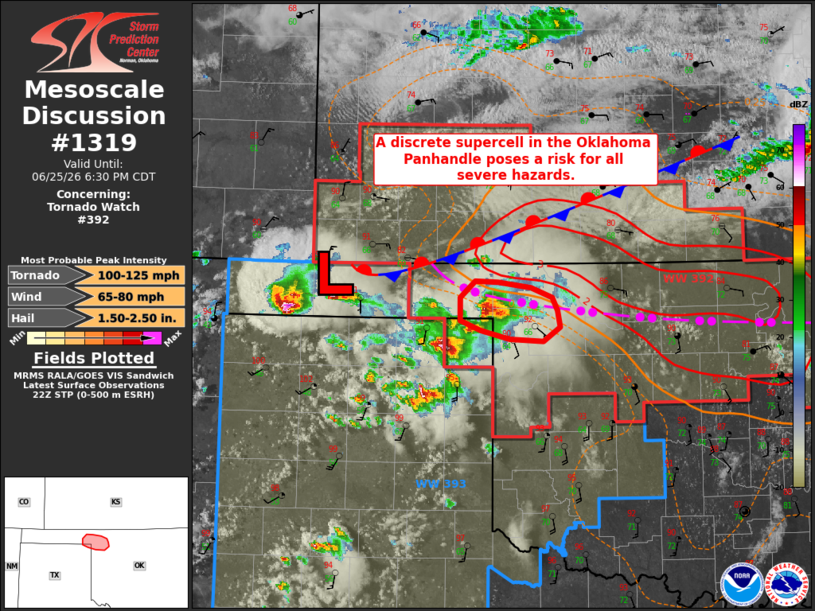
Mesoscale Discussion 1319 NWS Storm Prediction Center Norman OK 0507 PM CDT Thu Jun 25 2026 Areas affected...portions of the eastern Oklahoma Panhandle...northeastern Texas Panhandle...and northwestern Oklahoma Concerning...Tornado Watch 392... Valid 252207Z - 252330Z The severe weather threat for Tornado Watch 392 continues. SUMMARY...A discrete supercell in the eastern Oklahoma Panhandle will pose a risk primarily for large to very large hail and damaging wind gusts over the next 1-2 hours. The tornado risk with this storm remains more uncertain. DISCUSSION...A discrete supercell has intensified along a remnant outflow boundary in Beaver County, Oklahoma over the past hour. A couple of tornadoes have been reported with this cell, and MRMS and other MESH estimates have ranged up to 4+ inches over the past 30-60 minutes. Given the favorable environment and the potential for this cell to remain largely discrete for another hour or two before it potentially interacts with convection to the southwest, large to very large hail (potentially up to 2+ inches in diameter) and damaging wind gusts will remain possible with this supercell. Bunkers right motion and the recent track of the supercell suggest that it may remain along the remnant outflow boundary. In this scenario, tornado potential will remain greater given the favorable low-level shear along/north of the outflow boundary (100+ 0-500 m SRH sampled by the VNX VAD profile). Should this supercell attain more of a southeastward track, however, it would encounter a drier, more well-mixed boundary layer exists (MLLCLs exceeding 2 km per latest objective analysis and the 18z AMA observed sounding), which would result in a lower tornado threat. ..Chalmers.. 06/25/2026 ...Please see www.spc.noaa.gov for graphic product... ATTN...WFO...OUN...AMA... LAT...LON 36530036 36680037 36840020 36839993 36779957 36699933 36569926 36429923 36299942 36309980 36380013 36480036 36530036 MOST PROBABLE PEAK TORNADO INTENSITY...100-125 MPH MOST PROBABLE PEAK WIND GUST...65-80 MPH MOST PROBABLE PEAK HAIL SIZE...1.50-2.50 IN |
|
|
Top/All Mesoscale Discussions/Forecast Products/Home |
|
Source link