| Mesoscale Discussion 1156 | |
| < Previous MD | |

|
|
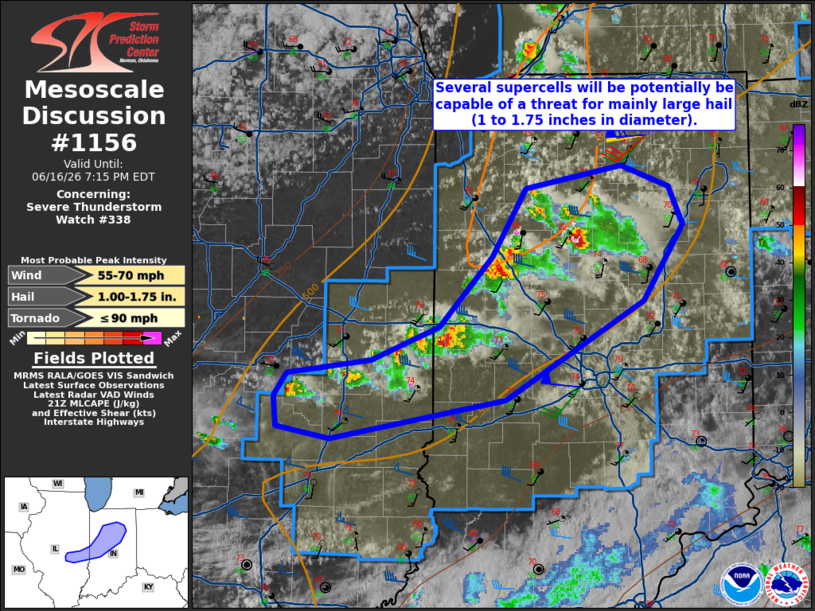
Mesoscale Discussion 1156 NWS Storm Prediction Center Norman OK 0450 PM CDT Tue Jun 16 2026 Areas affected...central IL into west-central and north-central IN Concerning...Severe Thunderstorm Watch 338... Valid 162150Z - 162315Z The severe weather threat for Severe Thunderstorm Watch 338 continues. SUMMARY...Several supercells will potentially be capable of a threat for mainly large hail (1 to 1.75 inches in diameter). Localized severe gusts (55-65 mph) are possible with the stronger cores. A brief tornado is also possible. DISCUSSION...Water-vapor imagery shows a potent upper shortwave trough moving east across the central Great Lakes. Surface analysis places a cold front from the mid MS Valley arching east-northeastward into east-central IL and northeastward into the southern Lake Michigan vicinity. This boundary is serving as the primary low-level forcing mechanism for storm development late this afternoon from central IL northeastward towards Lafayette, IN. Ahead of these storms---which contain a few supercell left-right splits---surface conditions of lower 70s deg F temperatures and mid 50s dewpoints are observed. RAP forecast soundings show cold 500-mb temperatures (-16 to -18 deg C) and gradually veering and strengthening flow with height beneath 80-kt 300 mb westerly flow. As a result, sufficient buoyancy/shear will continue to support supercells for the next several hours. Large hail appears to be the primary severe hazard, but localized severe gusts and perhaps a brief tornado are also possible. ..Smith.. 06/16/2026 ...Please see www.spc.noaa.gov for graphic product... ATTN...WFO...IWX...IND...LOT...ILX... LAT...LON 40268572 39618691 39368841 39438886 39638888 39788878 39888806 40098748 40568702 41018674 41158592 41018550 40778538 40268572 MOST PROBABLE PEAK TORNADO INTENSITY...UP TO 90 MPH MOST PROBABLE PEAK WIND GUST...55-70 MPH MOST PROBABLE PEAK HAIL SIZE...1.00-1.75 IN |
|
|
Top/All Mesoscale Discussions/Forecast Products/Home |
|
Source link