| Mesoscale Discussion 1119 | |
| < Previous MD Next MD > | |

|
|
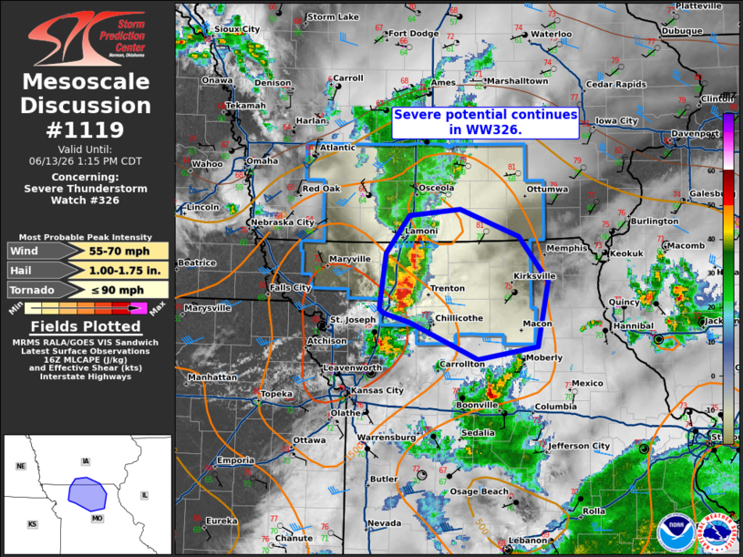
Mesoscale Discussion 1119 NWS Storm Prediction Center Norman OK 1151 AM CDT Sat Jun 13 2026 Areas affected...far southern Iowa into north-central Missouri Concerning...Severe Thunderstorm Watch 326... Valid 131651Z - 131815Z The severe weather threat for Severe Thunderstorm Watch 326 continues. SUMMARY...Damaging wind and isolated hail potential continues in WW326. DISCUSSION...A line of thunderstorms continues eastward across far southern Iowa into north-central Missouri, producing more recent gusts in to around 55-60 mph. Guidance suggests this will continue eastward for another couple of hours across northern Missouri. Sufficient MLCAPE around 1000 J/kg and deep layer shear around 30 kts will support potential for strong to severe wind and perhaps some isolated instances of hail. This will eventually weaken with time ahead of new convection developing to the west and as outflow from a complex of storms moves northward this afternoon. A downstream watch is not likely to be needed. ..Thornton.. 06/13/2026 ...Please see www.spc.noaa.gov for graphic product... ATTN...WFO...LSX...DVN...DMX...EAX... LAT...LON 40469413 40829385 40899322 40639248 40199212 39579225 39469300 39809383 39899416 39939422 40469413 MOST PROBABLE PEAK TORNADO INTENSITY...UP TO 90 MPH MOST PROBABLE PEAK WIND GUST...55-70 MPH MOST PROBABLE PEAK HAIL SIZE...1.00-1.75 IN |
|
|
Top/All Mesoscale Discussions/Forecast Products/Home |
|
Source link