| Mesoscale Discussion 1103 | |
| < Previous MD | |

|
|
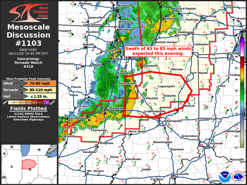
Mesoscale Discussion 1103 NWS Storm Prediction Center Norman OK 0819 PM CDT Thu Jun 11 2026 Areas affected...central into north-central Indiana Concerning...Tornado Watch 318... Valid 120119Z - 120245Z The severe weather threat for Tornado Watch 318 continues. SUMMARY...A swath of 65 to 85 mph winds are expected across central to north-central Indiana this evening. DISCUSSION...A mature bow-echo has developed across east-central Illinois with a strong rear-inflow jet. This bow has left a large swath of wind damage over the past hour including a measured 68 mph wind gust in Champaign, IL. 65 to 85 mph winds are expected to continue across a relatively wide swath as it moves east into a very unstable environment through the evening. Some embedded QLCS tornadoes will also be possible, especially north of the apex of the bow, but the strong measured wind gusts will be the primary threat. ..Bentley.. 06/12/2026 ...Please see www.spc.noaa.gov for graphic product... ATTN...WFO...IWX...IND...LOT...ILX... LAT...LON 41078755 41238663 41128546 40668505 40208541 39938647 39938707 39988761 40498752 41078755 MOST PROBABLE PEAK TORNADO INTENSITY...85-110 MPH MOST PROBABLE PEAK WIND GUST...75-90 MPH MOST PROBABLE PEAK HAIL SIZE...UP TO 1.25 IN |
|
|
Top/All Mesoscale Discussions/Forecast Products/Home |
|
Source link