| Mesoscale Discussion 1098 | |
| < Previous MD | |

|
|
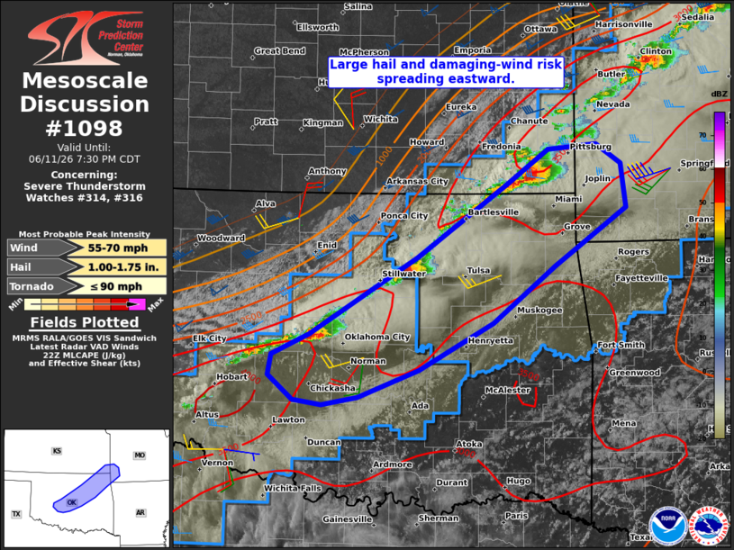
Mesoscale Discussion 1098 NWS Storm Prediction Center Norman OK 0556 PM CDT Thu Jun 11 2026 Areas affected...Parts of central/northeast OK...southeast KS...and southwest MO Concerning...Severe Thunderstorm Watch 314...316... Valid 112256Z - 120030Z The severe weather threat for Severe Thunderstorm Watch 314, 316 continues. SUMMARY...Risk of large hail and damaging winds spreading eastward across central/northeastern Oklahoma and southeast Kansas -- within Severe Thunderstorm Watches 314 and 316. DISCUSSION...Semi-discrete supercell structures are evolving eastward along a northeast/southwest-oriented cold front extending from southeast KS across northeast/central OK. Along this segment of the cold front, around 30 kt of deep-layer shear (per VWP data) and storm motions directed off the boundary should continue to promote semi-discrete supercell structures with a risk of large hail and damaging winds in the near term. With time, an increasingly parallel component of the deep-layer flow/shear to the front and strengthening cold pools should favor upscale growth into a line of storms, which will promote more of a damaging wind risk. ..Weinman.. 06/11/2026 ...Please see www.spc.noaa.gov for graphic product... ATTN...WFO...SGF...TSA...ICT...OUN... LAT...LON 35349842 35569796 36349660 37089548 37449495 37509434 37299404 36859398 36259488 35679565 35209659 34929735 34849780 34889815 35149847 35349842 MOST PROBABLE PEAK TORNADO INTENSITY...UP TO 90 MPH MOST PROBABLE PEAK WIND GUST...55-70 MPH MOST PROBABLE PEAK HAIL SIZE...1.00-1.75 IN |
|
|
Top/All Mesoscale Discussions/Forecast Products/Home |
|
Source link