| Mesoscale Discussion 988 | |
| < Previous MD | |

|
|
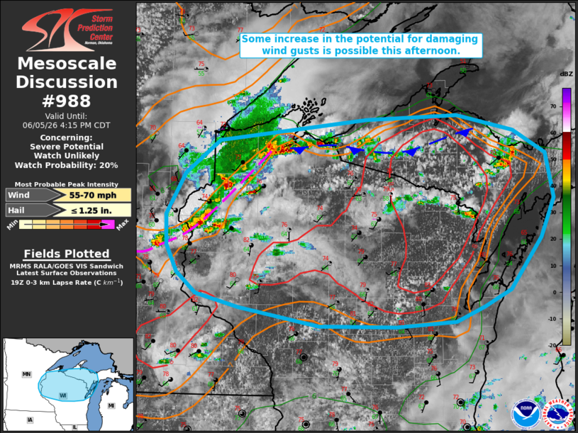
   Mesoscale Discussion 0988
   NWS Storm Prediction Center Norman OK
   0238 PM CDT Fri Jun 05 2026

   Areas affected...portions of northern Wisconsin into western Upper
   Michigan

   Concerning...Severe potential...Watch unlikely

   Valid 051938Z - 052115Z

   Probability of Watch Issuance...20 percent

   SUMMARY...Some increase in the potential for damaging wind gusts is
   possible this afternoon as storms evolve eastward across northern
   Wisconsin and western Upper Michigan. Small to marginally severe
   hail also remains possible with any stronger storms.

   DISCUSSION...Ongoing convection just east of the WI/MN border has
   shown some signs of upscale growth into a bowing segment/cluster
   along an outflow boundary over the past hour. Additional
   thunderstorm development is also noted along an east-west oriented
   lake breeze inland of the southern shore of Lake Superior. While
   this convection has largely remained sub-severe through 1930 UTC,
   producing a report of pea sized hail and a measured gust of 48 mph,
   steepening low-level lapse rates and increasing buoyancy amid
   continued diurnal heating (per latest mesoanalysis) may support some
   increase in the potential for damaging wind gusts through this
   afternoon as this cluster progresses eastward. Small to marginally
   severe hail also remains possible with the most robust cores even
   though mid-level lapse rates weaken with eastward extent.

   Despite the increasing thunderstorm coverage and potential for an
   uptick in damaging wind potential, weak effective shear (20-25 kts
   or less) is expected to largely temper storm organization and
   severity. Thus, watch issuance remains unlikely at this time.

   ..Chalmers/Mosier.. 06/05/2026

   ...Please see www.spc.noaa.gov for graphic product...

   ATTN...WFO...MQT...GRB...DLH...ARX...MPX...

   LAT...LON   46569220 46818967 46878812 46688715 46408660 45868646
               45398669 44778723 44568768 44388816 44338917 44349047
               44559184 44719257 44969289 45289308 45659309 46169277
               46569220

   MOST PROBABLE PEAK WIND GUST...55-70 MPH
   MOST PROBABLE PEAK HAIL SIZE...UP TO 1.25 IN
|
|
|
Top/All Mesoscale Discussions/Forecast Products/Home |
|
Source link