

| Mesoscale Discussion 930 | |
| < Previous MD | |

|
|
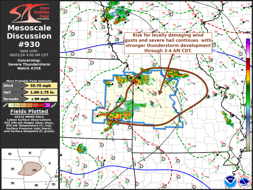
Mesoscale Discussion 0930 NWS Storm Prediction Center Norman OK 0154 AM CDT Mon Jun 01 2026 Areas affected...parts of eastern Kansas through central Missouri Concerning...Severe Thunderstorm Watch 258... Valid 010654Z - 010900Z The severe weather threat for Severe Thunderstorm Watch 258 continues. SUMMARY...Risk for damaging wind gusts and severe hail continues in stronger thunderstorm development, which may increasingly become focused near the I-70 corridor of western into central Missouri through 3-4 AM CDT. DISCUSSION...Ongoing storms are embedded within modest (20-25+ kt), broadly anticyclonic westerly deep-layer ambient mean flow, with increasing inhibition probably becoming a more substantive factor concerning storm intensities and organization. Inhibition has been increasing with continued slow boundary-layer cooling, and latest Rapid Refresh suggests this may be aided further over the next few hours by mid-layer warming and height rises, particularly across southeastern Kansas through southwestern Missouri. Convective evolution through daybreak remains unclear. However, a narrow southwesterly low-level jet, on the order of 20-30 kt below 1.5 km AGL, gradually veering with time may focus strongest low-level warm advection across the Lake of the Ozarks vicinity into areas west of Columbia through 08-09Z. As this occurs, this may shift the primary corridor of stronger and upscale growing convective development roughly along I-70. ..Kerr.. 06/01/2026 ...Please see www.spc.noaa.gov for graphic product... ATTN...WFO...LSX...SGF...EAX...TOP...ICT... LAT...LON 38949481 39669384 39469168 38709104 37989232 37539346 37739578 38439503 38949481 MOST PROBABLE PEAK TORNADO INTENSITY...UP TO 90 MPH MOST PROBABLE PEAK WIND GUST...55-70 MPH MOST PROBABLE PEAK HAIL SIZE...1.00-1.75 IN |
|
|
Top/All Mesoscale Discussions/Forecast Products/Home |
|
Source link