| Mesoscale Discussion 821 | |
| < Previous MD | |
|
|
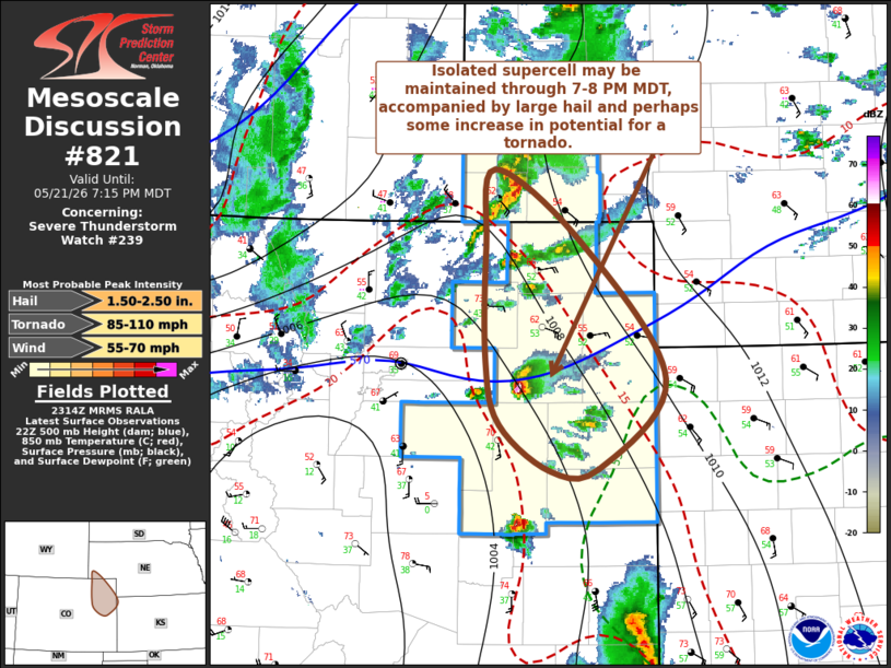
Mesoscale Discussion 0821 NWS Storm Prediction Center Norman OK 0616 PM CDT Thu May 21 2026 Areas affected...parts of southwestern Nebraska...northeast and east central Colorado...adjacent northwestern Kansas Concerning...Severe Thunderstorm Watch 239... Valid 212316Z - 220115Z The severe weather threat for Severe Thunderstorm Watch 239 continues. SUMMARY...Isolated to widely scattered supercell development is likely to persist through 6-8 PM MDT, accompanied by the risk for large hail and perhaps some increase in potential for a tornado near the Colorado/Kansas state border to the west-northwest of Goodland. DISCUSSION...Isolated thunderstorm development has undergone notable intensification the past few hours, aided by destabilization associated with continued boundary-layer warming and moistening. This appears to have contributed to CAPE on the order of 1000-1500, in the presence of strong westerly deep-layer shear, though with mean ambient winds on the order of 20-30 kt, due to the veering of winds with height. Of the ongoing storms, the prominent supercell to the north-northeast of Limon CO appears to have the longest access to unstable inflow as it propagates eastward toward the Kansas state border to the west-northwest of Goodland through 7-8 PM MDT. It appears that this may coincide with enlarging low-level hodographs accompanying strengthening east-southeasterly 850 mb flow, which may promote some further increase in potential for a tornado or two. ..Kerr.. 05/21/2026 ...Please see www.spc.noaa.gov for graphic product... ATTN...WFO...GLD...BOU...CYS... LAT...LON 39890379 40800380 41420371 40840280 39750194 39040262 39020312 39380365 39890379 MOST PROBABLE PEAK TORNADO INTENSITY...85-110 MPH MOST PROBABLE PEAK WIND GUST...55-70 MPH MOST PROBABLE PEAK HAIL SIZE...1.50-2.50 IN |
|
|
Top/All Mesoscale Discussions/Forecast Products/Home |
|
Source link