|
|
| Mesoscale Discussion 821 | |
| < Previous MD | |

|
|
   Mesoscale Discussion 0821
   NWS Storm Prediction Center Norman OK
   0917 PM CDT Fri May 17 2024

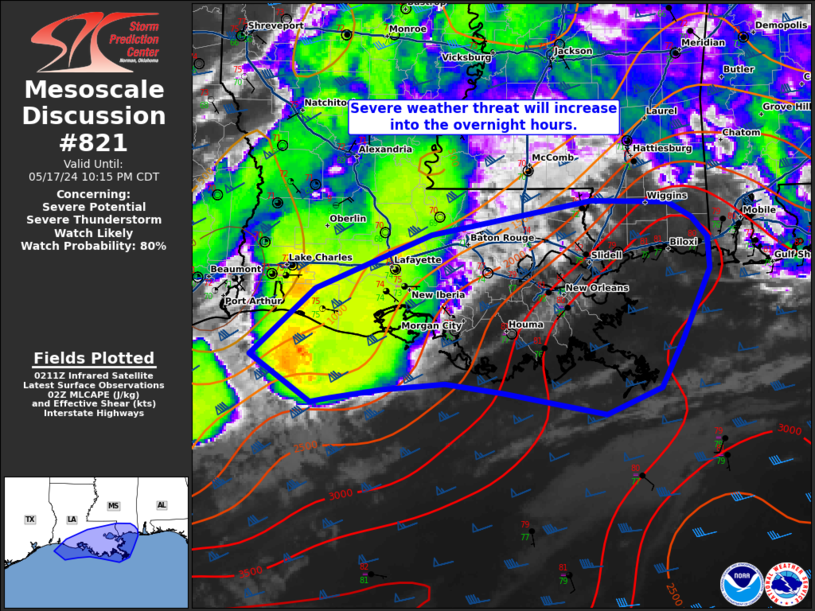
   Areas affected...southern Louisiana and far southern Mississippi

   Concerning...Severe potential...Severe Thunderstorm Watch likely

   Valid 180217Z - 180315Z

   Probability of Watch Issuance...80 percent

   SUMMARY...The severe weather threat will increase into the overnight
   hours across southern Louisiana and far southern Mississippi.

   DISCUSSION...A very moist Gulf airmass is in place across southern
   Louisiana this evening with a 18.5 mean mixing ratio on the 00Z LIX
   RAOB and mid to upper 70s dewpoints across most of the Delta. This
   deep moisture is supporting 2500 to 4000 J/kg MUCAPE (per SPC
   mesoanalysis) which should be maintained for much of the overnight
   period across the region. Strong shear (60 to 70 knots) will support
   supercells with a primary threat of large hail and damaging wind
   gusts. Weak low-level flow, per LIX 00Z RAOB and HDC VWP, combined
   with weak low-level lapse rates and at least partially elevated
   inflow bases, should limit the tornado threat during the overnight
   period.

   A severe thunderstorm watch is likely by 03Z to cover the overnight
   supercell threat.

   ..Bentley/Smith.. 05/18/2024

   ...Please see www.spc.noaa.gov for graphic product...

   ATTN...WFO...MOB...LIX...LCH...

   LAT...LON   29339361 29999288 30539157 30878975 30868887 30708861
               30508843 30198841 29518871 29028896 28778959 28979075
               29079140 29009212 28919270 28879291 29339361
|
|
|
Top/All Mesoscale Discussions/Forecast Products/Home |
|


