| Mesoscale Discussion 813 | |
| < Previous MD Next MD > | |

|
|
Mesoscale Discussion 0813
NWS Storm Prediction Center Norman OK
0202 PM CDT Thu May 21 2026
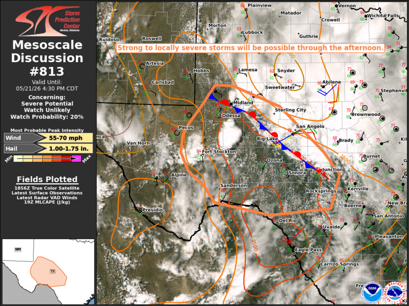
Areas affected...Parts of west/southwest TX
Concerning...Severe potential...Watch unlikely
Valid 211902Z - 212130Z
Probability of Watch Issuance...20 percent
SUMMARY...Strong to locally severe storms will be possible through
the afternoon.
DISCUSSION...A small supercell has recently developed to the
northeast of Midland. With generally weak deep-layer flow noted in
regional VWPs, the relative organization of this cell is likely due
to locally backed winds and enhanced shear/SRH in the vicinity of a
differential heating/baroclinic zone draped from north to east of
Midland. This cell and any other cell that can mature within this
zone may continue to move southeastward along the boundary, with
moderate MLCAPE supporting a threat of large hail. Localized strong
to severe gusts may also occur.
Additional storms have recently developed near and east/northeast of
Fort Stockton. Deep-layer shear is weaker in this region compared to
areas farther north near the boundary, but MLCAPE of near/above 2000
J/kg will support at least transient robust updrafts, with a threat
of hail and localized strong to severe gusts.
..Dean/Hart.. 05/21/2026
...Please see www.spc.noaa.gov for graphic product...
ATTN...WFO...EWX...SJT...MAF...
LAT...LON 32450206 31990082 30969969 30449930 29689954 29550109
29840251 30160276 30530319 30950339 31310335 31580321
32020285 32460252 32450206
MOST PROBABLE PEAK WIND GUST...55-70 MPH
MOST PROBABLE PEAK HAIL SIZE...1.00-1.75 IN
|
|
|
Top/All Mesoscale Discussions/Forecast Products/Home |
|
Source link