| Mesoscale Discussion 810 | |
| < Previous MD | |

|
|
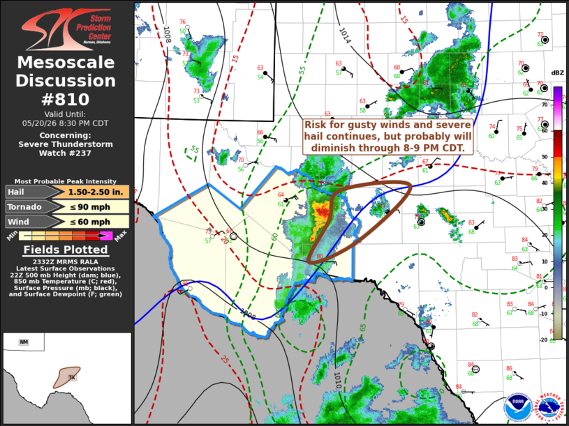
Mesoscale Discussion 0810 NWS Storm Prediction Center Norman OK 0642 PM CDT Wed May 20 2026 Areas affected...Texas Big Bend into Pecos Valley Concerning...Severe Thunderstorm Watch 237... Valid 202342Z - 210130Z CORRECTED WORDING IN LAST SENTENCE OF TEXT The severe weather threat for Severe Thunderstorm Watch 237 continues. SUMMARY...A small cluster of storms continues to pose some risk for severe hail and wind, but this potential probably will diminish while spreading toward the San Angelo vicinity through 8-9 PM CDT. DISCUSSION...Strongest storms have been maintained on the northeastern flank of convective outflow slowly propagating off the higher terrain, in the presence of strongly sheared (due to veering of winds with height) but weak southwesterly deep-layer mean flow on the order of 15-20 kt. This is where northeasterly surface winds to the cool side of a weakening surface front may be enhancing convergence along the outflow, and low-level warm advection above the front may be still maximized. However, latest guidance suggests that this forcing may begin to weaken within the next couple of hours, resulting in diminishing convective intensities, if an influx of less unstable updraft inflow does not weaken convection sooner. ..Kerr.. 05/20/2026 ...Please see www.spc.noaa.gov for graphic product... ATTN...WFO...SJT...MAF... LAT...LON 30620214 31030196 31090081 30320167 30030245 30620214 MOST PROBABLE PEAK TORNADO INTENSITY...UP TO 90 MPH MOST PROBABLE PEAK WIND GUST...UP TO 60 MPH MOST PROBABLE PEAK HAIL SIZE...1.50-2.50 IN |
|
|
Top/All Mesoscale Discussions/Forecast Products/Home |
|
Source link