| Mesoscale Discussion 786 | |
| < Previous MD | |

|
|
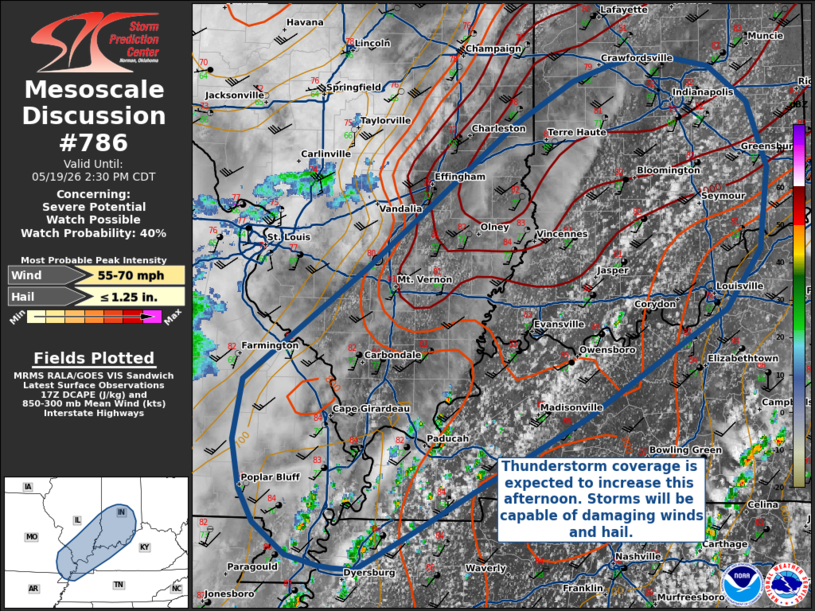
   Mesoscale Discussion 0786
   NWS Storm Prediction Center Norman OK
   1231 PM CDT Tue May 19 2026

   Areas affected...Lower Ohio River Valley

   Concerning...Severe potential...Watch possible

   Valid 191731Z - 191930Z

   Probability of Watch Issuance...40 percent

   SUMMARY...Thunderstorm coverage is expected to increase this
   afternoon across much of the Ohio River Valley as daytime heating
   brings the boundary layer to convective temperatures. These storms
   will primarily be capable of damaging straight-line winds and hail.

   DISCUSSION...Thunderstorms have begun to develop within moist and
   uncapped boundary layers where MLCAPE exceeds 2500 J/kg. Convective
   coverage is expected to increase throughout the afternoon, though
   will remain disorganized initially due to a lack of deep-layer
   shear. Still, large environmental DCAPE, steep low-level lapse
   rates, and relatively high PWATs will support strong downdrafts
   capable of damaging wind gusts. Localized corridors of increased
   threat could occur with any local organization along leading-edge
   outflow boundaries or with outflow boundary interactions.

   ..Halbert/Hart.. 05/19/2026

   ...Please see www.spc.noaa.gov for graphic product...

   ATTN...WFO...ILN...LMK...IND...PAH...ILX...MEG...LSX...

   LAT...LON   37589038 38458917 39578772 39918713 40028678 40098648
               40098622 40028577 39748540 39228521 38588528 38138563
               37308700 36448861 36388874 36108926 36118947 36148962
               36228993 36469026 36739039 37109047 37589038

   MOST PROBABLE PEAK WIND GUST...55-70 MPH
   MOST PROBABLE PEAK HAIL SIZE...UP TO 1.25 IN
|
|
|
Top/All Mesoscale Discussions/Forecast Products/Home |
|
Source link