| Mesoscale Discussion 778 | |
| < Previous MD | |

|
|
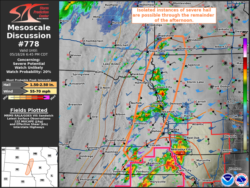
   Mesoscale Discussion 0778
   NWS Storm Prediction Center Norman OK
   0510 PM CDT Mon May 18 2026

   Areas affected...portions of far eastern Nebraska into western Iowa
   and extreme southern Minnesota

   Concerning...Severe potential...Watch unlikely

   Valid 182210Z - 182345Z

   Probability of Watch Issuance...20 percent

   SUMMARY...A couple instances of severe hail may occur with some of
   the stronger storms. The severe threat is expected to remain
   isolated.

   DISCUSSION...Multicells and transient supercell structures have been
   gradually intensifying within a WAA regime north of the warm front.
   21Z mesoanalysis depicts 1000-2000 J/kg of MUCAPE and 35-45 kts of
   effective bulk shear, suggesting that storms may achieve some degree
   of organization, with severe hail possible with the stronger, more
   persistent updrafts. However, storms are tracking into an
   environment characterized by decreasing buoyancy and shear, putting
   total severe coverage in question. As such, a WW issuance is not
   currently anticipated.

   ..Squitieri/Mosier.. 05/18/2026

   ...Please see www.spc.noaa.gov for graphic product...

   ATTN...WFO...DMX...FSD...OAX...GID...

   LAT...LON   44049575 44039529 43519516 42159568 41279617 40699658
               40419706 40439741 40699765 41379731 42779689 43479657
               43859626 44049575

   MOST PROBABLE PEAK WIND GUST...55-70 MPH
   MOST PROBABLE PEAK HAIL SIZE...1.50-2.50 IN
|
|
|
Top/All Mesoscale Discussions/Forecast Products/Home |
|
Source link