| Mesoscale Discussion 760 | |
| < Previous MD | |

|
|
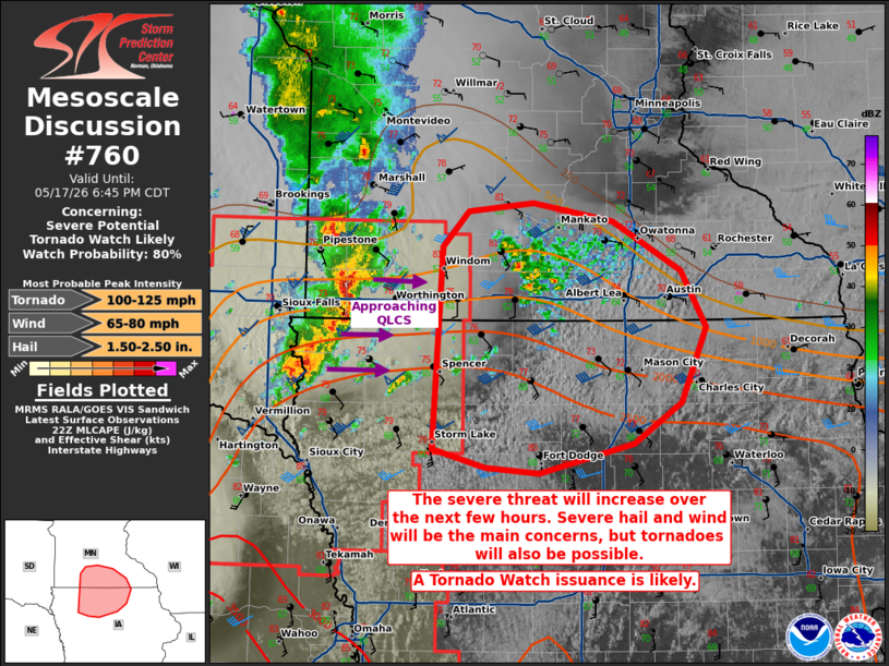
   Mesoscale Discussion 0760
   NWS Storm Prediction Center Norman OK
   0545 PM CDT Sun May 17 2026

   Areas affected...portions of northern Iowa into southern Minnesota

   Concerning...Severe potential...Tornado Watch likely

   Valid 172245Z - 172345Z

   Probability of Watch Issuance...80 percent

   SUMMARY...The severe threat will increase over the next few hours.
   Severe wind and hail are likely, with tornadoes also possible. A
   Tornado Watch may be needed soon to address the impending threat.

   DISCUSSION...A bowing QLCS is traversing the far western IA/MN
   border, with a recent history of marginal severe hail/wind occurring
   with an embedded supercell structure. This QLCS is tracking eastward
   toward the axis of a 30-40 kt low-level jet, where low-level shear
   is increasing (i.e. 200+ m2/s2 effective SRH per 22Z mesoanalysis).
   Furthermore, 8+ C/km mid-level lapse rates are overspreading upper
   60s to near 70 F surface dewpoints in the warm sector ahead of the
   QLCS, yielding up to 3000 J/kg MLCAPE. With 40+ kts of effective
   bulk shear also in place, potential exists for the QLCS to
   strengthen, with a corresponding increase in severe wind and hail
   potential. Line-embedded tornadoes may also occur, especially with
   portions of the QLCS that interact with an approaching warm front. A
   Tornado Watch may need to be issued in the next couple of hours.

   ..Squitieri/Smith.. 05/17/2026

   ...Please see www.spc.noaa.gov for graphic product...

   ATTN...WFO...ARX...MPX...DMX...FSD...

   LAT...LON   42589521 44019511 44269487 44329424 44209347 43859281
               43459256 42919281 42629326 42429418 42469470 42589521

   MOST PROBABLE PEAK TORNADO INTENSITY...100-125 MPH
   MOST PROBABLE PEAK WIND GUST...65-80 MPH
   MOST PROBABLE PEAK HAIL SIZE...1.50-2.50 IN
|
|
|
Top/All Mesoscale Discussions/Forecast Products/Home |
|
Source link