| Mesoscale Discussion 738 | |
| < Previous MD | |

|
|
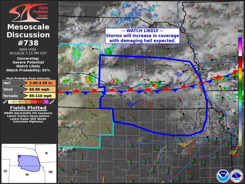
   Mesoscale Discussion 0738
   NWS Storm Prediction Center Norman OK
   0442 PM CDT Sat May 16 2026

   Areas affected...much of central into southeast Nebraska and
   northern Kansas

   Concerning...Severe potential...Watch likely

   Valid 162142Z - 170015Z

   Probability of Watch Issuance...95 percent

   SUMMARY...Storms are expected to become more numerous through this
   evening, with areas of damaging hail and wind expected.

   DISCUSSION...A quasi-stationary front extends from southern IA
   across southern NE and into northeast KS, with scattered convection
   along the length of it. Surface winds are easterly within this zone,
   with 35-40 kt midlevel southwest flow aloft. The result is around 50
   kt deep layer shear.

   Meanwhile, daytime heating as well as moisture advection/boundary
   layer deepening has led to moderate instability. Forecast soundings
   still show steep lapse rates aloft despite subtle height rises, and
   this should foster a few storms with very large hail. A damaging
   wind threat may develop over time as storms ride along the boundary.

   Storms may form into northeast KS which is south of the boundary.
   Here, visible imagery shows substantial CU developing with the moist
   axis where dewpoints are in the mid 60s F. The modified 18Z TOP
   soundings shows an uncapped air mass. Shear is not as strong with
   southward extend, but sufficient for at least short-lived severe
   hail or wind.

   ..Jewell/Smith.. 05/16/2026

   ...Please see www.spc.noaa.gov for graphic product...

   ATTN...WFO...EAX...OAX...TOP...GID...LBF...GLD...

   LAT...LON   40699572 40229559 39699562 39259581 39139633 39139707
               39239787 39499882 39589959 40009964 39990017 40330018
               40479999 40709999 40700024 41760023 41699754 41549629
               41049589 40699572

   MOST PROBABLE PEAK TORNADO INTENSITY...85-110 MPH
   MOST PROBABLE PEAK WIND GUST...65-80 MPH
   MOST PROBABLE PEAK HAIL SIZE...2.00-3.50 IN
|
|
|
Top/All Mesoscale Discussions/Forecast Products/Home |
|
Source link