| Mesoscale Discussion 733 | |
| < Previous MD | |

|
|
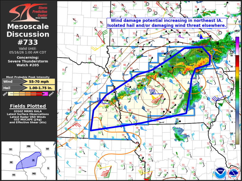
Mesoscale Discussion 0733 NWS Storm Prediction Center Norman OK 1053 PM CDT Fri May 15 2026 Areas affected...eastern Nebraska into central and northeast Iowa Concerning...Severe Thunderstorm Watch 205... Valid 160353Z - 160600Z The severe weather threat for Severe Thunderstorm Watch 205 continues. SUMMARY...Through 05:00 UTC (12:00 AM CDT), the greatest threat for strong to severe wind gusts (up to 70 mph) will exist east of I-35 in northeast Iowa. DISCUSSION...Recent trends in mosaic radar data indicate an evolving QLCS extending from a bookend vortex and adjacent, small-scale bow nearing the MS River in far northeast IA south-southwest to a couple of additional bowing structures near Oelwein and west of Waterloo. The greatest damaging wind potential (gusts up to 70 mph possible) will exist with those structures as they continue east at 35-40 kt, and eventually move into the recently issued Severe Thunderstorm Watch 207. Elsewhere, more sporadic occurrences of marginally severe hail and/or locally strong wind gusts will be possible along the cold front from near Omaha northeast to south and southeast of Fort Dodge. Surface observations indicate a pocket of drier air in place across western IA, which is an artifact from earlier convection. The drier air coupled with a gradually cooling boundary-layer are expected to limit overall storm intensity across the western half of the watch area. ..Mead.. 05/16/2026 ...Please see www.spc.noaa.gov for graphic product... ATTN...WFO...DVN...ARX...DMX...EAX...FSD...OAX... LAT...LON 40299727 41079718 41649657 42199550 42459501 42609429 43039337 43429260 43459168 43129129 42809132 42659206 42279226 41719238 41269250 40989257 40629479 40299727 MOST PROBABLE PEAK WIND GUST...55-70 MPH MOST PROBABLE PEAK HAIL SIZE...1.00-1.75 IN |
|
|
Top/All Mesoscale Discussions/Forecast Products/Home |
|
Source link