| Mesoscale Discussion 640 | |
| < Previous MD Next MD > | |
|
|
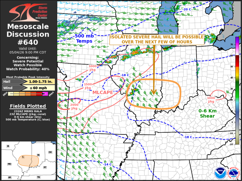
   Mesoscale Discussion 0640
   NWS Storm Prediction Center Norman OK
   0634 PM CDT Mon May 04 2026

   Areas affected...South-central Illinois and Southern Indiana

   Concerning...Severe potential...Watch possible

   Valid 042334Z - 050200Z

   CORRECTED FOR WORDING

   Probability of Watch Issuance...40 percent

   SUMMARY...An isolated severe threat for large hail is expected to
   continue for a few hours across south-central Illinois, and may
   affect southern Indiana. The need for weather watch issuance is
   uncertain.

   DISCUSSION...A couple cells have recently develop to the northeast
   of the St. Louis metro. The activity is located along the eastern
   edge of a pocket of moderate instability, where the RAP has MLCAPE
   around 1000 J/kg. The storms are being supported by an area of
   low-level convergence and by large-scale ascent associated with a
   subtle shortwave trough, evident on water vapor imagery. The WSR-88D
   VWP near St Louis has effective shear in the 30 to 40 knot range,
   and the RAP shows very steep mid-level lapse rates exceeding 7.5
   C/km. This should be favorable for large hail with supercells that
   form. However, a capping inversion is evident over much of
   southeastern Illinois and southern Indiana. Also, RAP suggests that
   instability is very weak in this same area. For this reason, the
   storms are expected to remain elevated, and the eastern extent of
   the severe threat is uncertain.

   ..Broyles/Hart.. 05/04/2026

   ...Please see www.spc.noaa.gov for graphic product...

   ATTN...WFO...LMK...IND...PAH...ILX...LSX...

   LAT...LON   38058802 38218956 38489008 38859021 39299012 39638974
               39798899 39748736 39618654 39338617 38828613 38318631
               38088688 38058802

   MOST PROBABLE PEAK WIND GUST...UP TO 60 MPH
   MOST PROBABLE PEAK HAIL SIZE...1.00-1.75 IN
|
|
|
Top/All Mesoscale Discussions/Forecast Products/Home |
|
Source link