| Mesoscale Discussion 310 | |
| < Previous MD | |
|
|
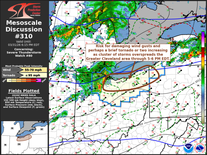
Mesoscale Discussion 0310 NWS Storm Prediction Center Norman OK 0322 PM CDT Tue Mar 31 2026 Areas affected...northern Ohio into northwestern Pennsylvania Concerning...Severe Thunderstorm Watch 80... Valid 312022Z - 312215Z The severe weather threat for Severe Thunderstorm Watch 80 continues. SUMMARY...Potential for damaging wind gusts, and perhaps a brief tornado or two, is likely to increase as an evolving cluster of storms overspreads much of the Greater Cleveland area by 5-6 PM EDT. DISCUSSION...An evolving cluster of thunderstorms continues to slowly intensify and organize. Though not yet well-defined, an associated lower/mid-tropospheric cyclonic circulation appears to be evolving, near/east of Toledo, with further intensification still possible, as convection maintains east/southeasterly inflow of unstable air characterized by mixed-layer CAPE up to 1000 J/kg for at least another few hours. Embedded within 40+ kt westerly deep-layer mean flow it appears that the convective system will overspread much of the Greater Cleveland area by 21-22Z, accompanied by potentially damaging wind gusts and perhaps a brief tornado or two. ..Kerr.. 03/31/2026 ...Please see www.spc.noaa.gov for graphic product... ATTN...WFO...PBZ...CLE... LAT...LON 41658283 41728168 42048053 41507995 41038131 40938306 41338312 41658283 MOST PROBABLE PEAK TORNADO INTENSITY...UP TO 95 MPH MOST PROBABLE PEAK WIND GUST...55-70 MPH |
|
|
Top/All Mesoscale Discussions/Forecast Products/Home |
|
Source link