Tropical Storm Roslyn, strengthening just off Mexico’s Pacific Coast on Friday, is expected to take a looping track that would bring it onshore just north of Puerto Vallarta on Sunday morning. As of 11 a.m. EDT Friday, Roslyn’s top winds were 65 mph, with a central pressure of 997 mb. The storm was about 180 miles south of Manzanillo, Mexico, heading west-northwest at 7 mph. A hurricane hunter flight planned for Friday afternoon was canceled for mechanical reasons.
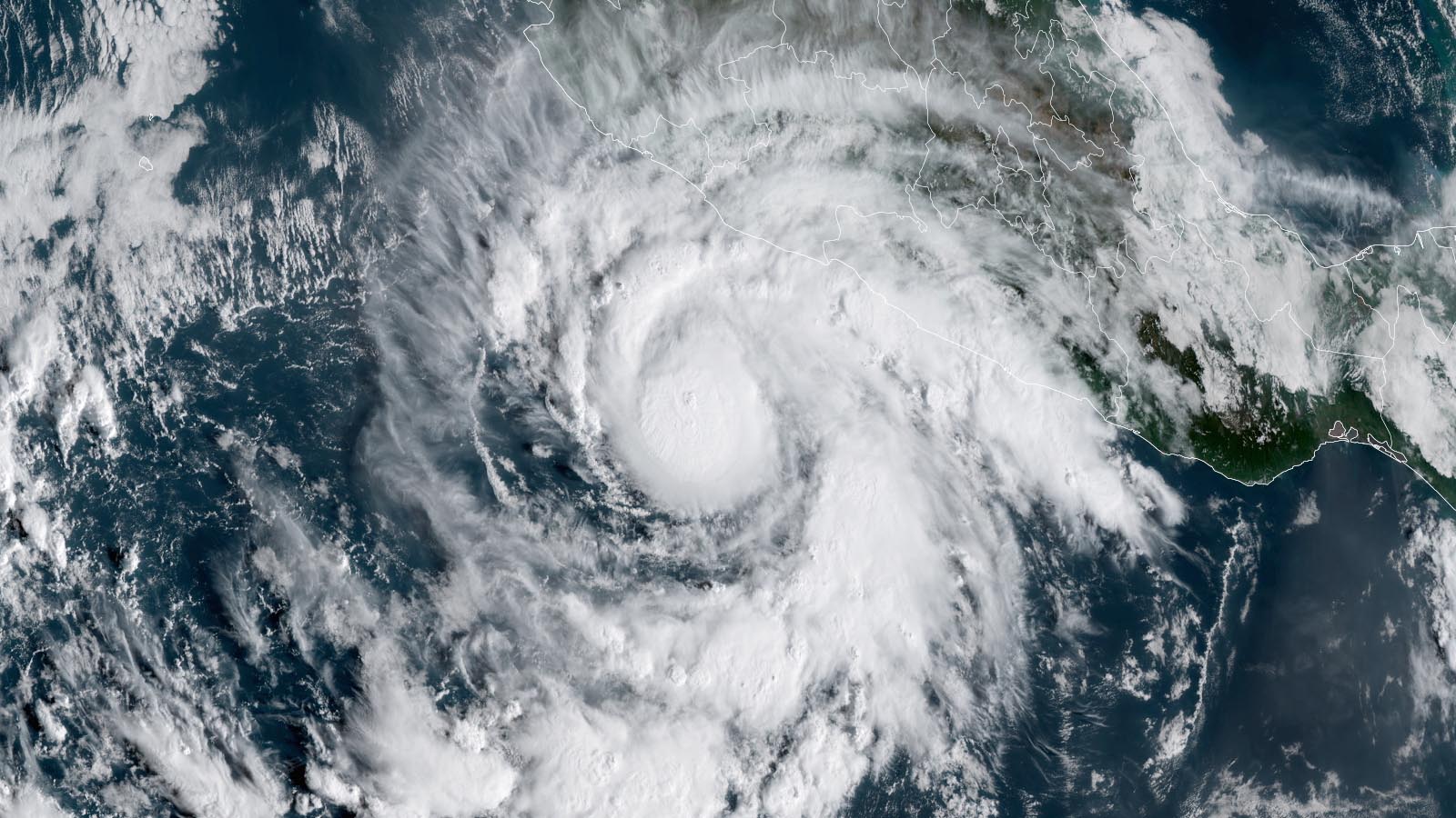
Satellite images on Friday afternoon showed that Roslyn’s small inner core was tightening and strengthening notably, as the storm took advantage of the broad field of atmospheric moisture that surrounded it. A number of prominent spiral bands of convection (showers and thunderstorms) were growing in intensity, and one of these was bringing heavy rain to the coast of Mexico.
Forecast for Roslyn
Roslyn is likely to attain at least category 2 strength before making landfall. The storm will traverse sea surface temperatures (SSTs) around 29 degrees Celsius (84 degrees Fahrenheit), and wind shear should remain light to moderate (less than 15 knots) through at least Saturday night. Roslyn will benefit also from a moderately moist mid-level atmosphere on Friday (relative humidity around 60-65%), and its inner core may be able to wall off the ill effects of a drier atmosphere from Saturday into Sunday, when mid-level relative humidity will be dropping to around 55%.
The SHIPS rapid intensification index issued at 8 a.m. EDT Friday gave a 32% chance of Roslyn’s sustained winds increasing to 100 mph (category 2) by 8 a.m. Saturday, and the newer DTOPS index gave 38% odds. SHIPS and DTOPS gave 23 and 28 percent odds, respectively, of Roslyn’s packing 115-mph winds (category 3) by Saturday evening. The National Hurricane Center predicts Roslyn will become a hurricane by Friday night, peaking as a high-end category 2 hurricane with 110 mph winds shortly before landfall on Sunday morning.
Land interaction will complicate Roslyn’s evolution as it approaches the coast. The storm’s center likely will pass near the coast just west of Puerto Vallarta on Saturday night, putting the city on its stronger right-hand side, before arcing north and northeast and making landfall on Sunday further north, between Puerto Vallarta and Mazatlan. Roslyn could be near its peak strength as it passes closest to Puerto Vallarta, but the land interaction, drier air, and slightly cooler SSTs could lead to some weakening before landfall.
In its 11 a.m. EDT Friday wind probability forecast, NHC gave Puerto Vallarta a 68% chance of experiencing tropical storm-force winds, and a 12% chance of hurricane-force winds. Mazatlan’s odds were 57% and 8%, respectively. Roslyn will be speeding up to a forward speed of about 15 mph near the time of landfall, which will limit the amount of rain the storm will drop. NHC predicts a much lower rainfall total than usual for a Mexican hurricane: peak amounts of 4 – 6 inches, with isolated areas of up 8 inches. But wind and storm surge damage will be high where Roslyn’s core makes landfall.
The strongest hurricane to make landfall between Puerto Vallarta and Mazatlan in reliable records was Kenna, a category 4 storm that struck near San Blas in late October 2002. Kenna took four lives and inflicted more than $100 million in damage (USD 2002).
After Roslyn quickly dissipates over the rugged terrain of western Mexico, its moisture will be pulled into the south-central United States ahead of a sharp upper-level storm system – perhaps contributing to welcome rainfall early next week across drought-stricken landscapes from Texas to Missouri.
Bay of Bengal storm expected to form this weekend
In the North Indian Ocean, the summertime southwest monsoon has receded, opening up the opportunity for that region’s October – November tropical cyclone season to grow active. Tropical cyclones are uncommon in the North Indian Ocean from June through September because of interference from the monsoon. But during October and November, it is common to see a few tropical cyclones form on the east side of India, in the Bay of Bengal, and on the west side of India, in the Arabian Sea.
An area of disturbed weather in the eastern Bay of Bengal, designated 92B, is expected to develop into a tropical storm this weekend and track toward India and Bangladesh. The disturbance has favorable conditions for development, with sea surface temperatures (SSTs) of 29 – 30 degrees Celsius (84-86°F), light to moderate wind shear of 5-15 knots, and a moist atmosphere. These SSTs are 1 degree Celsius (1.8°F) above average. Satellite images on Friday showed that 92B with a modest-sized area of heavy thunderstorms steadily growing more organized, with some rotation of the cloud pattern evident.
Steering currents favor a west-northwesterly track for 92B through Saturday, and then a sharp turn to the north-northeast on Sunday, thanks to the steering influence of a trough of low pressure passing to the north. Landfall is expected in Bangladesh on Monday or Tuesday. The landfall intensity of 92B will depend on how long the storm is over water; a faster forward speed and an earlier landfall would likely not give 92B enough time to intensify into a category 1-strength cyclone. Given this situation, the 6Z Friday run of the GFS model predicted landfall near 18Z Monday as a strong tropical storm. However, a slower forward speed would give the storm more time over water, potentially allowing 92B to intensify into a highly destructive hurricane-strength cyclone. This was the forecast of the 6Z Friday run of the HWRF, which predicted 92B would make landfall near 6Z Tuesday as a high-end category 2 storm with 110 mph winds. The India Meteorology Department is predicting that 92B will peak as a category 1-equivalent cyclone at 12Z on Tuesday, shortly before landfall in Bangladesh.
The next name on the Indian Ocean list of storms is Sitrang.


The Atlantic is quiet
High wind shear rules in the tropical Atlantic, and high wind shear is predicted to dominate for the next seven days, making tropical cyclone formation there difficult. Wind shear is predicted to be lower in the subtropical Atlantic between the Bahamas and Bermuda, and that is a more likely place for tropical cyclone formation during the coming week. By the end of October, the GFS model suggests, wind shear may decrease over the southern Caribbean, allowing greater chances for tropical cyclone formation there. SSTs in both regions are running up to 0.5 degree Celsius (0.9°F) above average, which would aid the development of any storms that manage to organize.
Invest 93W in the western Pacific a potential threat to the Philippines
An area of disturbed weather, designated 93W, in the western Pacific near the Mariana Islands, was headed west toward the Philippines with the potential to organize into a tropical storm by Wednesday, as predicted by the Friday morning runs of the GFS and European models. This system has long-range potential to become a typhoon, and residents of the Philippines should watch this system.
Website visitors can comment on “Eye on the Storm” posts (see comments policy below). Sign up to receive notices of new postings here.
Source link