|
|
| Mesoscale Discussion 997 | |
| < Previous MD | |

|
|
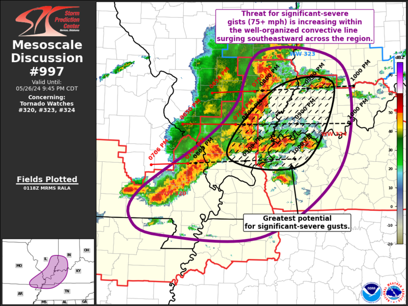
Mesoscale Discussion 0997 NWS Storm Prediction Center Norman OK 0821 PM CDT Sun May 26 2024 Areas affected...Southern IL...Western KY...Southeast MO/MO Bootheel...Far Western TN Concerning...Tornado Watch 320...323...324... Valid 270121Z - 270245Z The severe weather threat for Tornado Watch 320, 323, 324 continues. SUMMARY...Threat for significant-severe gusts is increasing within the ongoing convective line from southeast Illinois and southern Indiana into western Kentucky and far southeast Missouri/Missouri Bootheel. DISCUSSION...Well-organized convective line continues to push quickly southeastward across southern IL and southeast MO/MO Bootheel. Recent storm motion with this line was estimated around 50 kt, which would bring the line into central KY and southern IN between 0230 and 0300Z. Several severe gusts have been noted within the line, including recently at KSLO at 56 kt. This northeast-to-southwest orientated line is about to intersect a west-to-east line of supercells across far southern IL into far southwest KY. This interaction is expected to result in intensification of the line, with some potential for this area to to surge eastward, becoming the apex of the bow. Significant-severe gusts (i.e. 75-90 mph) are likely within this vicinity over the next few hours. Northern portion of the bow remains well-organized, with some interaction with the newly strengthening warm-air advection cells across southern IN. Significant-severe gusts appear possible here as well. An embedded supercell persists at the southern end of the line, with another supercell in its wake to the west over Carter County MO. Both of these cells will continue to pose a risk for all severe hazards for the next hour or two. ..Mosier.. 05/27/2024 ...Please see www.spc.noaa.gov for graphic product... ATTN...WFO...LMK...OHX...IND...PAH...ILX...MEG...LSX...LZK... LAT...LON 39328827 39058655 37388660 36218822 36219039 36489102 36959086 37838950 38408885 39328827 |
|
|
Top/All Mesoscale Discussions/Forecast Products/Home |
|


