|
|
| Mesoscale Discussion 984 | |
| < Previous MD Next MD > | |

|
|
   Mesoscale Discussion 0984
   NWS Storm Prediction Center Norman OK
   0342 PM CDT Sun May 26 2024

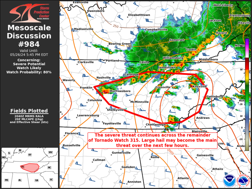
   Areas affected...portions of Middle into eastern Tennessee

   Concerning...Severe potential...Watch likely

   Valid 262042Z - 262145Z

   Probability of Watch Issuance...80 percent

   SUMMARY...The severe threat continues across portions of middle into
   eastern Tennessee. Large hail is becoming the main concern as storms
   become more supercellular through the afternoon. A couple of
   tornadoes also cannot be ruled out. Either a new WW issuance or
   local expansions of existing watches are needed.

   DISCUSSION...A line of thunderstorms has gradually transitioned to a
   more supercellular mode over the past couple of hours, with a
   dominant supercell recently producing severe hail. Other supercells
   are beginning to form in the warm sector as well, including in spots
   where the airmass remains pristine. Given ample buoyancy/shear and
   the more cellular mode, severe hail will become the main threat over
   Middle into eastern TN over the next few hours, though a couple of
   tornadoes and damaging gusts are still possible. As such, either a
   new WW issuance or expansion of existing watches is needed to
   address the present severe weather scenario.

   ..Squitieri/Bunting.. 05/26/2024

   ...Please see www.spc.noaa.gov for graphic product...

   ATTN...WFO...GSP...MRX...OHX...

   LAT...LON   35998683 36378522 36308381 35938345 35408371 35158422
               35118481 35388573 35588637 35998683
|
|
|
Top/All Mesoscale Discussions/Forecast Products/Home |
|


