|
|
| Mesoscale Discussion 979 | |
| < Previous MD Next MD > | |

|
|
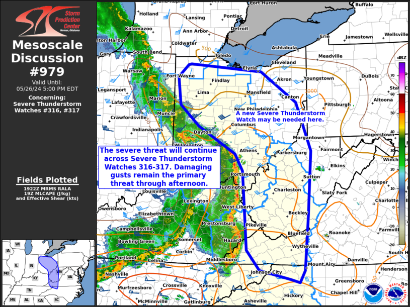
Mesoscale Discussion 0979 NWS Storm Prediction Center Norman OK 0225 PM CDT Sun May 26 2024 Areas affected...portions of western and central Ohio...extreme eastern Kentucky...western West Virginia...extreme western Virginia...extreme western North Carolina Concerning...Severe Thunderstorm Watch 316...317... Valid 261925Z - 262100Z The severe weather threat for Severe Thunderstorm Watch 316, 317 continues. SUMMARY...Damaging gusts (some severe) should remain possible across Severe Thunderstorm Watches 316 and 317 over the next few hours as a QLCS moves across the region. An additional Severe Thunderstorm Watch may also be needed downstream, near the OH/PA border area. DISCUSSION...A long-lived QLCS, with an extensive history of strong and damaging wind gusts, continues to track across eastern portions of the OH into central Appalachians. Low to mid 80s F surface temperatures precede the QLCS, with the boundary layer mixed enough to support a continued threat of damaging gusts for at least a few more hours. This favorable airmass extends to the OH/PA border area, downstream of both the severe thunderstorm watches, so an additional Severe Thunderstorm Watch may be needed in the next hour or so. ..Squitieri/Bunting.. 05/26/2024 ...Please see www.spc.noaa.gov for graphic product... ATTN...WFO...RNK...PBZ...RLX...CLE...MRX...JKL...ILN...IWX... LAT...LON 36208109 36448206 36938246 38038252 38908258 39328282 39568326 39998399 40518458 41218467 41518435 41528426 41348199 40588088 39388041 37788053 36438065 36138080 36208109 |
|
|
Top/All Mesoscale Discussions/Forecast Products/Home |
|


