|
|
| Mesoscale Discussion 971 | |
| < Previous MD | |

|
|
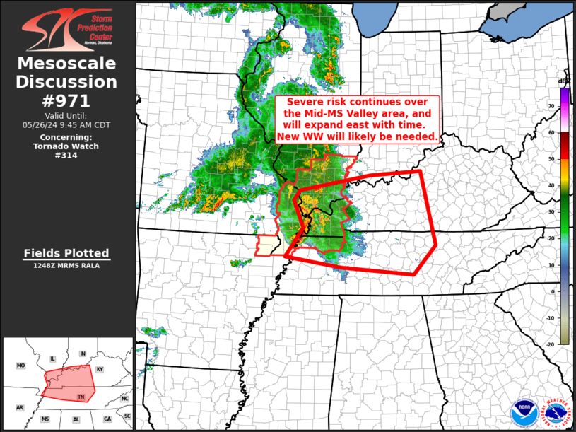
Mesoscale Discussion 0971 NWS Storm Prediction Center Norman OK 0750 AM CDT Sun May 26 2024 Areas affected...Mid Mississippi Valley into central Kentucky/Middle Tennessee Concerning...Tornado Watch 314... Valid 261250Z - 261445Z The severe weather threat for Tornado Watch 314 continues. SUMMARY...Severe risk -- including a couple of tornadoes along with damaging wind gusts and hail -- continues across Tornado Watch 314. Risk will eventually spread east of this watch, likely warranting downstream WW issuance into central Kentucky and Middle Tennessee, and potentially southern Indiana. DISCUSSION...Latest radar loop shows that convection has evolved into a bowing MCS across southeastern Missouri, and now moving across the Mississippi Valley, with embedded small-scale circulations embedded therein. As such, risk for a couple of tornadoes continues, along with more widespread potential for damaging winds/hail. Downstream from the ongoing convection, ample instability appears to extend eastward as far as central Kentucky and Middle Tennessee. Given the well-organized nature of this MCS -- including the MCV/mesolow apparent in southeastern Missouri -- expect that storms will remain organized as they shift eastward, accompanied by continued severe risk over the next few hours at least. While the watch currently runs through 26/15Z, risk likely continuing beyond this time/downstream from the eastern edge of the watch will likely require new WW issuance in the 14Z to 1430Z time frame. ..Goss.. 05/26/2024 ...Please see www.spc.noaa.gov for graphic product... ATTN...WFO...LMK...OHX...PAH...MEG... LAT...LON 35968991 36728934 37418966 37688948 38078722 38178558 36268514 35518585 35718813 35968991 |
|
|
Top/All Mesoscale Discussions/Forecast Products/Home |
|


