|
|
| Mesoscale Discussion 961 | |
| < Previous MD | |

|
|
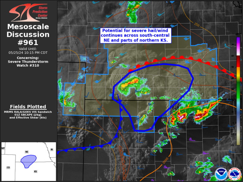
Mesoscale Discussion 0961 NWS Storm Prediction Center Norman OK 0822 PM CDT Sat May 25 2024 Areas affected...Northwest Kansas into southern Nebraska Concerning...Severe Thunderstorm Watch 310... Valid 260122Z - 260315Z The severe weather threat for Severe Thunderstorm Watch 310 continues. SUMMARY...The threat for severe hail and wind continues across portions of northwest Kansas into southern Nebraska. Thunderstorm coverage and intensity may increase in the next couple of hours based on recent observed trends and latest numerical guidance. DISCUSSION...Recent GOES water-vapor and visible imagery continue to show signs of persistent, broadscale ascent within the left-exit region of the primary mid-level jet that is nosing into western/central OK. This persistent ascent has resulted in scattered thunderstorm development along a cold front across southwest NE/northwest KS over the past hour. IR imagery and MRMS data have shown periodic intensification of this activity, and while buoyancy continues to slowly increase amid northward moisture return, ongoing thunderstorms across north-central KS may limit addition moisture return and modulate further destabilization. The expectation for the next couple of hours is for continued periodic intensification of this activity with additional development along the front possible. Thunderstorm clusters should propagate to the east/northeast over the next few hours with an attendant risk of large hail and severe winds. This idea is supported by recent HRRR solutions and derived hazard probability forecasts, which show hail and wind potential increasing downstream through at least 03 UTC. ..Moore.. 05/26/2024 ...Please see www.spc.noaa.gov for graphic product... ATTN...WFO...GID...LBF...GLD... LAT...LON 39170029 39590046 39890076 40030106 40370103 40750048 40949980 40989925 40959873 40869839 40589822 40279838 40019872 39589935 39539947 39229969 39169995 39170029 |
|
|
Top/All Mesoscale Discussions/Forecast Products/Home |
|


