|
|
| Mesoscale Discussion 951 | |
| < Previous MD Next MD > | |

|
|
   Mesoscale Discussion 0951
   NWS Storm Prediction Center Norman OK
   0141 PM CDT Sat May 25 2024

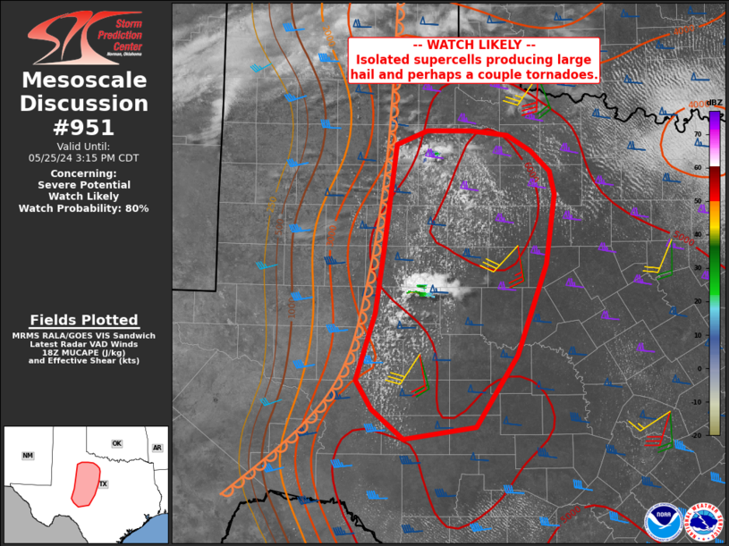
   Areas affected...parts of west-central into northwest Texas

   Concerning...Severe potential...Watch likely

   Valid 251841Z - 252015Z

   Probability of Watch Issuance...80 percent

   SUMMARY...Isolated supercells are expected to form over the next 1-2
   hours along the dryline over west-central into parts of northwest
   TX. Very large hail and a couple tornadoes will be possible.

   DISCUSSION...Surface analysis shows an extremely moist air mass with
   70s F dewpoints extending west toward the Snyder/Sweetwater area,
   along a developing dryline. Strong heating will aid further
   destabilization and CIN removal, as low-level convergence gradually
   increase near the dryline.

   Visible imagery already shows towers forming in this area,
   suggesting at least isolated supercells will soon form. Extreme
   instability as well as impressive mid to high level winds will
   strongly favor very large and damaging hail. Although the primary
   tornado risk is forecast north of this area later today, a couple
   tornadoes appear likely with the southern supercells given favorable
   storm mode, impressive updrafts, and gradually increasingly
   low-level SRH through early evening.

   ..Jewell/Bunting.. 05/25/2024

   ...Please see www.spc.noaa.gov for graphic product...

   ATTN...WFO...FWD...OUN...SJT...LUB...MAF...

   LAT...LON   31080128 31790105 32460094 33610079 33770040 33779985
               33729938 33549907 33339884 33079877 32329888 31359926
               30589978 30450069 30770109 31080128
|
|
|
Top/All Mesoscale Discussions/Forecast Products/Home |
|


