| Mesoscale Discussion 940 | |
| < Previous MD Next MD > | |

|
|
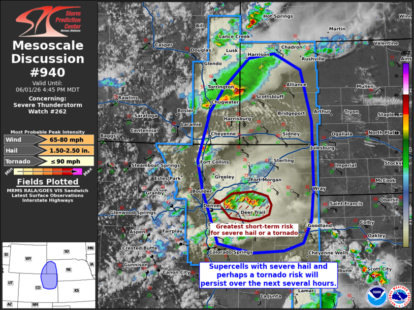
Mesoscale Discussion 0940 NWS Storm Prediction Center Norman OK 0438 PM CDT Mon Jun 01 2026 Areas affected...portions of southeast Wyoming into eastern Colorado and western Nebraska Concerning...Severe Thunderstorm Watch 262... Valid 012138Z - 012245Z The severe weather threat for Severe Thunderstorm Watch 262 continues. SUMMARY...Supercells will continue across southeastern Wyoming into eastern Colorado over the next few hours, accompanied by a severe hail threat. A tornado is also possible. DISCUSSION...Multiple supercells, with a history of severe hail and occasional low-level rotation (especially over CO east of Denver), persist amid appreciable low-level upslope flow and 40 kts of effective bulk shear, but marginal instability (i.e. 1000 J/kg MLCAPE). Given 8+ C/km mid-level lapse rates preceding the ongoing storms, severe hail should continue over the next several hours. KFTG and TDEN storm relative velocity data have shown low-level rotation with storms east of Denver to be relatively brief. Nonetheless, ample low-level vertical oriented vorticity exists near these storms, so a landspout/hybrid tornado cannot be ruled out if an updraft can ingest this vorticity for an appreciable amount of time before being undercut by outflow. ..Squitieri.. 06/01/2026 ...Please see www.spc.noaa.gov for graphic product... ATTN...WFO...LBF...GLD...PUB...BOU...CYS... LAT...LON 39060458 40120498 40670512 41630482 42110446 42670382 42770315 42440248 41440219 40180216 39530222 39070244 38920292 38890371 39060458 MOST PROBABLE PEAK TORNADO INTENSITY...UP TO 90 MPH MOST PROBABLE PEAK WIND GUST...65-80 MPH MOST PROBABLE PEAK HAIL SIZE...1.50-2.50 IN |
|
|
Top/All Mesoscale Discussions/Forecast Products/Home |
|
Source link