|
|
| Mesoscale Discussion 929 | |
| < Previous MD Next MD > | |

|
|
   Mesoscale Discussion 0929
   NWS Storm Prediction Center Norman OK
   1157 AM CDT Fri May 24 2024

   Areas affected...northern and central Missouri...west-central
   Illinois

   Concerning...Severe potential...Watch possible

   Valid 241657Z - 241900Z

   Probability of Watch Issuance...60 percent

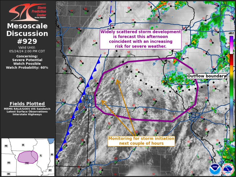
   SUMMARY...Widely scattered storm development is forecast this
   afternoon coincident with an increasing risk for severe weather.
   Large to very large hail is possible (1-2.5 inches in diameter),
   strong/locally damaging to severe gusts (55-70 mph), and possibly a
   couple of tornadoes.

   DISCUSSION...Visible satellite imagery shows a swelling cumulus
   field across far eastern KS and northwest/western MO ahead of a cold
   front gradually pushing east across the lower MO Valley.  A morning
   severe MCS --currently approaching Lake Michigan-- has resulted in
   an outflow boundary becoming draped from central IL westward into
   northeast MO and arcing northwestward into far south-central IA.
   South-southwesterly low-level flow will advect higher theta-e as the
   airmass destabilizes gradually from southwest to east-northeast
   across northeast MO and west-central IL.

   Forecast soundings for early this afternoon show a very unstable
   airmass (3500 J/kg MLCAPE) across northern/central MO south of the
   outflow boundary.  Effective shear around 30 kt will support
   organized storms, including supercells and severe multicells
   (especially once additional storms develop and congeal their
   outflows).  The hail risk will be greatest with any supercell that
   develops given 8.0 deg C/km 700-500 mb lapse rates and large
   buoyancy.  If the outflow boundary and air immediately on the cool
   side can modify appreciably over the next few hours, it is possible
   a tornado threat develops with storms that can favorably interact
   with the zone of augmented low-level shear.

   ..Smith/Guyer.. 05/24/2024

   ...Please see www.spc.noaa.gov for graphic product...

   ATTN...WFO...ILX...LSX...DVN...SGF...EAX...

   LAT...LON   40049403 40439299 40569103 40189029 39609006 39029019
               38509115 38559270 38749395 38979432 39369437 40049403
|
|
|
Top/All Mesoscale Discussions/Forecast Products/Home |
|


