| Mesoscale Discussion 834 | |
| < Previous MD | |

|
|
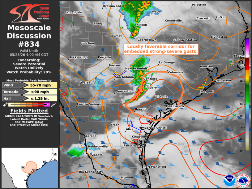
   Mesoscale Discussion 0834
   NWS Storm Prediction Center Norman OK
   0200 AM CDT Sat May 23 2026

   Areas affected...Parts of south-central TX to the Middle TX Coast

   Concerning...Severe potential...Watch unlikely

   Valid 230700Z - 230900Z

   Probability of Watch Issuance...20 percent

   SUMMARY...An isolated strong-severe gust (55-65 mph) cannot be ruled
   out with an evolving band of storms during the next couple hours.

   DISCUSSION...A small band of thunderstorms has evolved about 50
   miles southeast of San Antonio TX, with recent echo tops approaching
   45-50 kft AGL. The pre-convective environment is characterized by
   fully modified Gulf moisture (middle/upper 70s dewpoints) and steep
   midlevel lapse rates (as sampled by the CRP 00Z sounding). This,
   combined with temperatures holding in the upper 70s F yielded a
   corridor of 3000 J/kg MLCAPE to the Middle TX Coast. This buoyancy
   and around 30 kt of line-orthogonal effective shear may support the
   continuation of this convective band to the coast, with an
   associated risk of an isolated strong-severe gust (55-65 mph).
   However, weak forcing for ascent and some low-level inhibition
   should tend to limit convective intensity/organization and the
   overall severe risk.

   ..Weinman/Smith.. 05/23/2026

   ...Please see www.spc.noaa.gov for graphic product...

   ATTN...WFO...HGX...CRP...EWX...

   LAT...LON   28309772 28589807 29049754 29549742 29679713 29679659
               29499611 29079594 28529616 28169658 28099697 28309772

   MOST PROBABLE PEAK TORNADO INTENSITY...UP TO 90 MPH
   MOST PROBABLE PEAK WIND GUST...55-70 MPH
   MOST PROBABLE PEAK HAIL SIZE...UP TO 1.25 IN
|
|
|
Top/All Mesoscale Discussions/Forecast Products/Home |
|
Source link