| Mesoscale Discussion 824 | |
| < Previous MD | |
|
|
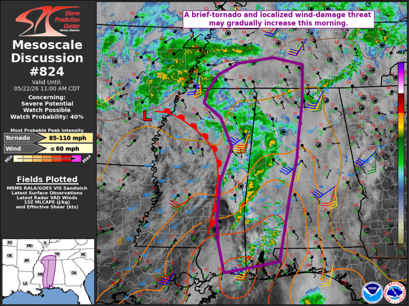
   Mesoscale Discussion 0824
   NWS Storm Prediction Center Norman OK
   0900 AM CDT Fri May 22 2026

   Areas affected...Parts of MS/AL into southern TN

   Concerning...Severe potential...Watch possible

   Valid 221400Z - 221600Z

   Probability of Watch Issuance...40 percent

   SUMMARY...Some increase in the brief-tornado and localized
   damaging-wind threat is possible with time into early afternoon.

   DISCUSSION...A midlevel vorticity maximum and attendant weak surface
   low are moving across eastern AR this morning. An arc of convection
   associated with this system extends across western TN into
   northern/eastern MS and western AL. The 12Z JAN/BMX soundings depict
   rich moisture and poor midlevel lapse rates, with around 25-35 kt of
   deep-layer shear and modestly enlarged low-level hodographs noted on
   regional VWPs.

   Filtered heating and modest destabilization in advance of this
   convective band may allow for some intensification through the
   morning into the early afternoon, though weak midlevel lapse rates
   may continue to hamper updraft strength. A belt of moderate
   low-level flow associated with the ejecting shortwave trough will
   maintain favorable low-level SRH, and transient supercell structures
   will continue to be possible through the morning, with a
   brief-tornado threat. A localized wind-damage threat may also
   increase with time, especially in areas where stronger heating and
   steepening of midlevel lapse rates occur. While uncertainty remains
   regarding coverage and magnitude of the threat, watch issuance is
   possible given the possibility of some increasing tornado potential
   with time.

   ..Dean/Hart.. 05/22/2026

   ...Please see www.spc.noaa.gov for graphic product...

   ATTN...WFO...OHX...BMX...HUN...MOB...MEG...JAN...LIX...

   LAT...LON   31678926 32648919 33538883 34258918 34628969 34938959
               35348926 35628864 35778758 35598669 34658673 33708686
               33248690 32478709 30668744 30398904 31158921 31678926

   MOST PROBABLE PEAK TORNADO INTENSITY...85-110 MPH
   MOST PROBABLE PEAK WIND GUST...UP TO 60 MPH
|
|
|
Top/All Mesoscale Discussions/Forecast Products/Home |
|
Source link