| Mesoscale Discussion 822 | |
| < Previous MD | |
|
|
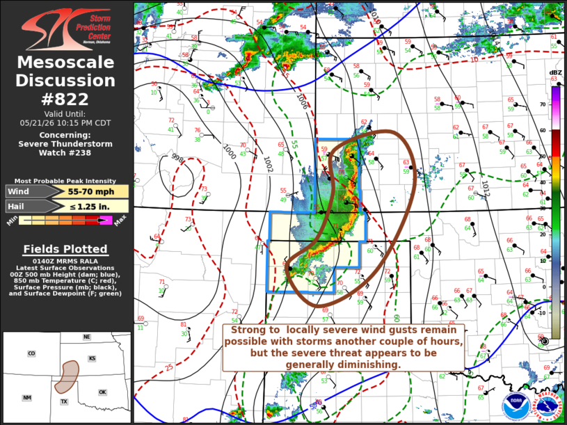
Mesoscale Discussion 0822 NWS Storm Prediction Center Norman OK 0843 PM CDT Thu May 21 2026 Areas affected...parts of southwestern Kansas and the Oklahoma/Texas Panhandle vicinity Concerning...Severe Thunderstorm Watch 238... Valid 220143Z - 220315Z The severe weather threat for Severe Thunderstorm Watch 238 continues. SUMMARY...Strong to locally severe wind gusts remain possible another couple of hours with the ongoing cluster of storms. However, sufficient weakening trends already appear underway to preclude the issuance of another severe weather watch and allow for the expiration of the current watch by 10 PM CDT. DISCUSSION...A couple of embedded meso-beta scale circulations have evolved and remain evident with the quasi-linear convective system propagating through the high plains, which has generated at least a narrow cold pool with 3-4 mb 2-hourly surface pressure rises sampled at Dalhart in the 01Z surface observations. However, forward motion has remained rather modest, and convective intensities appear to be trending downward. The onset of diurnal boundary-layer cooling, coupled with continued warming in lower/mid-levels, will lead to increasing inhibition through the evening, which is expected to maintain weakening convective trends and diminishing severe weather potential. ..Kerr.. 05/22/2026 ...Please see www.spc.noaa.gov for graphic product... ATTN...WFO...DDC...AMA... LAT...LON 36040262 36540199 37330165 38060162 38360032 37459989 35990072 35370195 36040262 MOST PROBABLE PEAK WIND GUST...55-70 MPH MOST PROBABLE PEAK HAIL SIZE...UP TO 1.25 IN |
|
|
Top/All Mesoscale Discussions/Forecast Products/Home |
|
Source link