| Mesoscale Discussion 820 | |
| < Previous MD Next MD > | |
|
|
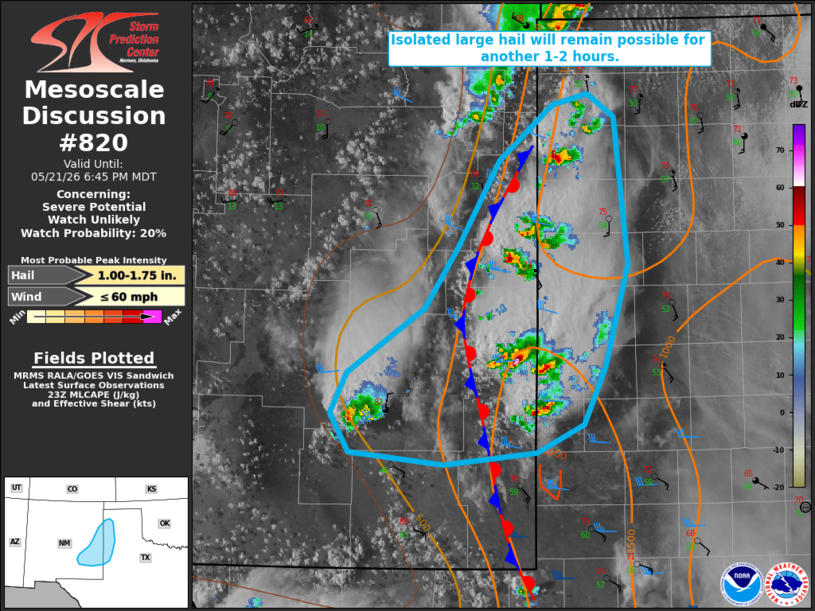
   Mesoscale Discussion 0820
   NWS Storm Prediction Center Norman OK
   0610 PM CDT Thu May 21 2026

   Areas affected...portions of eastern New Mexico into the western
   Texas Panhandle

   Concerning...Severe potential...Watch unlikely

   Valid 212310Z - 220045Z

   Probability of Watch Issuance...20 percent

   SUMMARY...Isolated large hail will remain possible with ongoing
   thunderstorms for another couple of hours. Watch issuance remains
   unlikely.

   DISCUSSION...Several ongoing thunderstorms are noted within a narrow
   corridor of locally greater surface-based buoyancy (1000-1500 J/kg
   MLCAPE per latest objective analysis) on the cool side of a
   quasi-stationary surface boundary where low-level moisture is
   greater. Modestly steep mid-level lapse rates (generally 7-8 C/km as
   sampled by the 18z AMA observed sounding) and greater effective
   shear (25-35 kts) within the vicinity of the surface baroclinic zone
   will continue to support a threat for isolated large hail with these
   ongoing storms. Recent MRMS and other MESH estimates support this,
   with values having ranged from 1-2" with these storms over the past
   hour. This potential is expected to persist for another 1-2 hours
   before convective intensity gradually wanes amid increasing
   inhibition and low-level cold advection.

   Farther west, an isolated, high-based thunderstorm has recently
   developed on the Sacramento Mountains. Isolated marginally severe
   hail and gusty winds may also accompany this cell as it develops
   eastward amid a drier, more well-mixed boundary layer.

   Given the limited spatial/temporal extent of this severe potential,
   watch issuance remains unlikely.

   ..Chalmers/Thompson.. 05/21/2026

   ...Please see www.spc.noaa.gov for graphic product...

   ATTN...WFO...LUB...AMA...MAF...ABQ...

   LAT...LON   32940305 32850395 32940489 33260506 33590490 34120414
               34630381 35330341 35800289 35880253 35700228 34480214
               33650237 33180258 32940305

   MOST PROBABLE PEAK WIND GUST...UP TO 60 MPH
   MOST PROBABLE PEAK HAIL SIZE...1.00-1.75 IN
|
|
|
Top/All Mesoscale Discussions/Forecast Products/Home |
|
Source link