| Mesoscale Discussion 819 | |
| < Previous MD | |
|
|
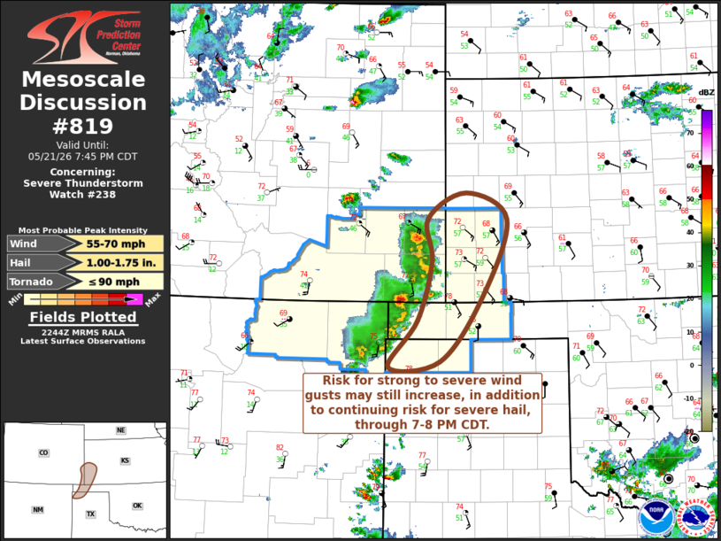
Mesoscale Discussion 0819 NWS Storm Prediction Center Norman OK 0546 PM CDT Thu May 21 2026 Areas affected...parts of southeastern Colorado...southwestern Kansas...and the Oklahoma/Texas Panhandles Concerning...Severe Thunderstorm Watch 238... Valid 212246Z - 220045Z The severe weather threat for Severe Thunderstorm Watch 238 continues. SUMMARY...The evolving thunderstorm cluster may organize further with increasing potential to produce strong to severe gusts, in addition to severe hail, through 7-8 PM CDT. DISCUSSION...Latest Rapid Refresh suggests that upscale convective growth the past few hours has been aided by focused lift driven by near-surface convergence within lee surface troughing and lower/mid-tropospheric warm advection. The evolving cluster now appears to be processing inflow of moistening boundary-layer air characterized by CAPE on the order of 1000-2000 J/kg in the peak late afternoon heating. In the presence of strong deep-layer westerly shear, further intensification and organization of convection appears probable through 23-01Z. Due to the pronounced veering of winds with height, southwesterly deep-layer ambient mean flow is only on the order of 20 kt, so eastward propagation may be modest, at least until the evolution of a strengthening cold pool supports possible acceleration this evening. ..Kerr.. 05/21/2026 ...Please see www.spc.noaa.gov for graphic product... ATTN...WFO...DDC...GLD...AMA...PUB... LAT...LON 38120234 38460169 38110099 37070141 36200213 36120299 36750250 37540226 38120234 MOST PROBABLE PEAK TORNADO INTENSITY...UP TO 90 MPH MOST PROBABLE PEAK WIND GUST...55-70 MPH MOST PROBABLE PEAK HAIL SIZE...1.00-1.75 IN |
|
|
Top/All Mesoscale Discussions/Forecast Products/Home |
|
Source link