| Mesoscale Discussion 803 | |
| < Previous MD | |
|
|
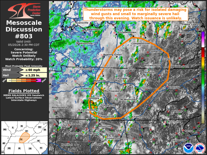
   Mesoscale Discussion 0803
   NWS Storm Prediction Center Norman OK
   1234 PM CDT Wed May 20 2026

   Areas affected...portions of Middle/eastern Tennessee into southern
   Kentucky

   Concerning...Severe potential...Watch unlikely

   Valid 201734Z - 201930Z

   Probability of Watch Issuance...20 percent

   SUMMARY...Widely scattered thunderstorms may pose a risk for
   isolated damaging wind gusts and small to marginally severe hail
   through this evening. Watch issuance is unlikely at this time.

   DISCUSSION...Recent radar imagery depicts increasing thunderstorm
   coverage across portions of Middle/eastern Tennessee and southern
   Kentucky amid continued diurnal heating of a moist low-level air
   mass (dewpoints in the mid/upper 60s F). Latest objective analysis
   depicts only weak buoyancy across the region, with MLCAPE around 500
   J/kg. Further destabilization is expected through peak heating this
   afternoon, a modified 12z BNA observed sounding suggesting that
   MLCAPE is likely approaching 1000 J/kg based on recent surface
   observations.

   While deep-layer flow remains weak across the region (less than 30
   kts of flow sampled through the column by the latest OHX VWP), 20-25
   kts of effective shear should be sufficient to support modest
   updraft organization into a multicellular storm mode. In conjunction
   with steepening low-level lapse rates, this may promote the
   potential for gusty to isolated damaging wind gusts (likely in the
   40-50 mph range) with any stronger, more well-organized clusters.
   Isolated small to marginally severe hail may also accompany the most
   robust updrafts despite poor mid-level lapse rates (5.5-6.0 C/km per
   latest mesoanalysis). Given the expectation for severe
   coverage/magnitude to remain limited, watch issuance is unlikely at
   this time.

   ..Chalmers/Hart.. 05/20/2026

   ...Please see www.spc.noaa.gov for graphic product...

   ATTN...WFO...MRX...JKL...LMK...OHX...HUN...

   LAT...LON   35788453 35418508 35058572 35018638 35208688 35548695
               35958683 36358658 37218594 37588530 37558493 37368442
               37068389 36748381 36258391 35788453

   MOST PROBABLE PEAK WIND GUST...UP TO 60 MPH
   MOST PROBABLE PEAK HAIL SIZE...UP TO 1.25 IN
|
|
|
Top/All Mesoscale Discussions/Forecast Products/Home |
|
Source link