| Mesoscale Discussion 211 | |
| < Previous MD | |

|
|
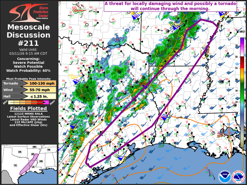
   Mesoscale Discussion 0211
   NWS Storm Prediction Center Norman OK
   0713 AM CDT Wed Mar 11 2026

   Areas affected...Parts of east TX into northwest LA and southern AR

   Concerning...Severe potential...Watch possible

   Valid 111213Z - 111415Z

   Probability of Watch Issuance...40 percent

   SUMMARY...Some threat for locally damaging wind and perhaps a
   tornado may continue through the morning.

   DISCUSSION...Convection has become better organized across parts of
   southern AR this morning, with additional robust development noted
   into parts of northwest LA and east TX. A general increase in storm
   coverage is expected with time as a mid/upper-level shortwave trough
   approaches the region from west TX. Some weakening and veering of
   low-level flow has been noted in regional VWPs, but deep-layer shear
   remains favorable, and seasonably rich low-level moisture will
   continue to support moderate buoyancy in advance of an approaching
   cold front.

   The severe threat may tend to remain rather isolated in the short
   term, though the strongest cells/clusters will be capable of
   producing locally damaging wind and perhaps a tornado. A more
   substantial increase in the coverage of the severe threat is
   expected later today, in response to the approaching shortwave
   trough.

   ..Dean/Mosier.. 03/11/2026

   ...Please see www.spc.noaa.gov for graphic product...

   ATTN...WFO...MEG...JAN...LZK...LCH...SHV...HGX...CRP...EWX...

   LAT...LON   33819108 31949264 30509388 29189596 28729680 28899701
               29649682 30039639 31319511 33749244 34509213 34969137
               34829080 34629053 33819108

   MOST PROBABLE PEAK TORNADO INTENSITY...100-130 MPH
   MOST PROBABLE PEAK WIND GUST...55-70 MPH
   MOST PROBABLE PEAK HAIL SIZE...UP TO 1.25 IN
|
|
|
Top/All Mesoscale Discussions/Forecast Products/Home |
|
Source link