| Mesoscale Discussion 1139 | |
| < Previous MD | |

|
|
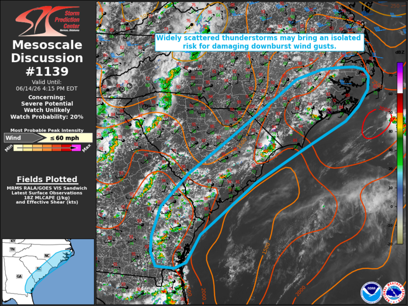
   Mesoscale Discussion 1139
   NWS Storm Prediction Center Norman OK
   0108 PM CDT Sun Jun 14 2026

   Areas affected...portions of the Southeast/Mid-Atlantic coast

   Concerning...Severe potential...Watch unlikely

   Valid 141808Z - 142015Z

   Probability of Watch Issuance...20 percent

   SUMMARY...Widely scattered thunderstorms will pose a risk for
   isolated damaging downburst wind gusts.

   DISCUSSION...Isolated to widely scattered thunderstorms have
   developed along and inland of the Atlantic Coast sea breeze across
   portions of coastal GA/SC/NC as of 18 UTC. Compared to areas farther
   inland, modestly greater low-level moisture dewpoints in the
   low-to-mid 70s are contributing to greater instability, with MLCAPE
   of 1500-2500 J/kg analyzed via latest objective analysis; although,
   a lingering warm layer sampled around 500 mb by the 12z MHX/CHS
   observed soundings may temper overall convective intensity. Weak
   effective shear (less than 20-25 kts) will also tend to limit
   overall updraft organization; however, high PWAT contents and
   steepening low-level lapse rates will support some potential for
   water-loaded downbursts, with occasionally damaging wind gusts
   possible. An instance or two of small hail may also occur with the
   most robust cores. Watch issuance appears unlikely at this time
   owing to the limited potential for convective organization and
   isolated nature of the severe threat.

   ..Chalmers/Mosier.. 06/14/2026

   ...Please see www.spc.noaa.gov for graphic product...

   ATTN...WFO...MHX...RAH...ILM...CHS...CAE...JAX...FFC...

   LAT...LON   32348213 33178135 33868040 34287982 35137866 35537810
               35777734 35807692 35827634 35757605 35587590 35247594
               34827625 34467663 33767797 32967934 31658096 30978134
               30818169 30868224 31218239 31618238 32348213

   MOST PROBABLE PEAK WIND GUST...UP TO 60 MPH
|
|
|
Top/All Mesoscale Discussions/Forecast Products/Home |
|
Source link