| Mesoscale Discussion 1134 | |
| < Previous MD | |

|
|
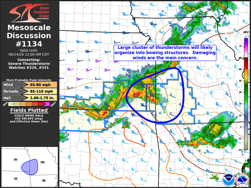
Mesoscale Discussion 1134 NWS Storm Prediction Center Norman OK 1004 PM CDT Sat Jun 13 2026 Areas affected...Southeast Kansas and Southwest Missouri Concerning...Severe Thunderstorm Watch 329...331... Valid 140304Z - 140500Z The severe weather threat for Severe Thunderstorm Watch 329, 331 continues. SUMMARY...Damaging winds will be possible for the next few hours as storms move across southeast KS into southwest MO. DISCUSSION...Radar loops show a large cluster of thunderstorms over southeast KS between Emporia and Joplin. This activity is moving through a moderately unstable air mass, but into an area that was overturned earlier today by widespread convection. Short-term trends suggest an upscale organization into a bowing MCS with an increased risk of damaging winds across southeast KS and far western MO. However, it is unclear how far east this threat may extend as storms move into the more stable air. ..Hart.. 06/14/2026 ...Please see www.spc.noaa.gov for graphic product... ATTN...WFO...SGF...EAX...TSA...TOP...ICT... LAT...LON 37349597 37979575 38359482 38589349 37279327 36629382 36619493 37349597 MOST PROBABLE PEAK TORNADO INTENSITY...85-110 MPH MOST PROBABLE PEAK WIND GUST...65-80 MPH MOST PROBABLE PEAK HAIL SIZE...1.00-1.75 IN |
|
|
Top/All Mesoscale Discussions/Forecast Products/Home |
|
Source link