|
|
| Mesoscale Discussion 1090 | |
| < Previous MD | |

|
|
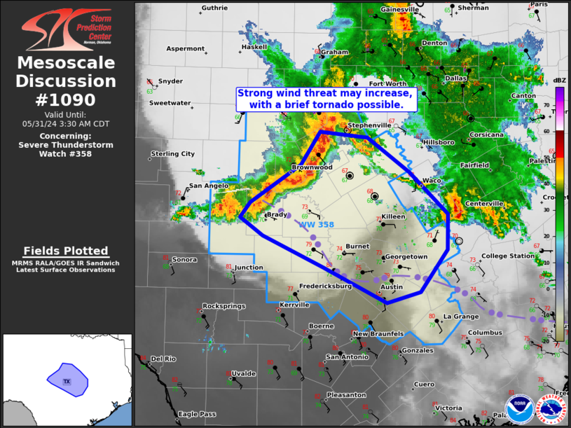
Mesoscale Discussion 1090 NWS Storm Prediction Center Norman OK 0206 AM CDT Fri May 31 2024 Areas affected...Central TX Concerning...Severe Thunderstorm Watch 358... Valid 310706Z - 310830Z The severe weather threat for Severe Thunderstorm Watch 358 continues. SUMMARY...The strong wind threat attendant to a QLCS may increase as it spreads east-southeast in central Texas. A brief tornado is also possible. DISCUSSION...A QLCS extending from Comanche to Concho County should continue to progress east-southeast across the Colorado River Valley of central TX. The northeast portion of the line has surged faster than the southwest portion, but is mainly crossing over the relatively cooler surface conditions north of prior convective outflow that extends from McCulloch County to the greater Austin area. Still, a gust to 44 kt was measured at the Brownwood AWOS. Farther south, closer to the remnant outflow boundary, a couple attempts at broader mesovortex formation have occurred within the enhanced low-level SRH environment. Additional attempts may yield corridors of enhanced severe wind gusts and potentially brief tornadogenesis as the QLCS impinges on the relatively warmer/more moist boundary-layer near/west of Austin. ..Grams.. 05/31/2024 ...Please see www.spc.noaa.gov for graphic product... ATTN...WFO...HGX...FWD...EWX...SJT... LAT...LON 32199857 32139790 31709731 31199677 30779677 30259716 30139763 30569851 30949937 31159969 31339954 31809884 32199857 |
|
|
Top/All Mesoscale Discussions/Forecast Products/Home |
|


