| Mesoscale Discussion 1073 | |
| < Previous MD | |

|
|
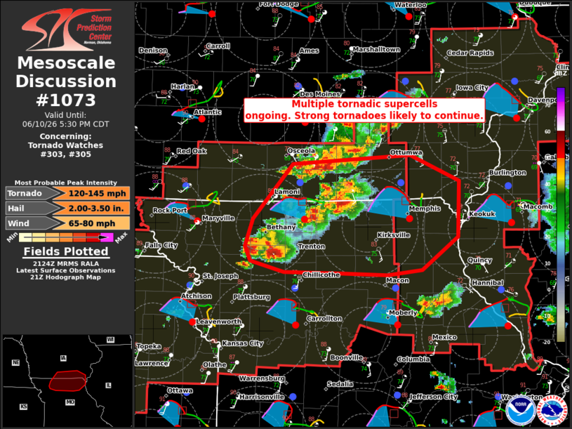
Mesoscale Discussion 1073 NWS Storm Prediction Center Norman OK 0427 PM CDT Wed Jun 10 2026 Areas affected...portions of northern Missouri and southern Iowa Concerning...Tornado Watch 303...305... Valid 102127Z - 102230Z The severe weather threat for Tornado Watch 303, 305 continues. SUMMARY...Multiple tornadic supercells are ongoing across northern MO and southern IA. The environment remains very favorable for tornadoes, some of which could be strong to intense. DISCUSSION...Recent radar imagery and storm reports show several tornadic supercells are ongoing across northern MO and southern IA in Tornado Watches 303 and 305. The environment downstream of these storms is modifying in the wake of an earlier MCS and remains highly conducive for supercells and tornadoes. Backed low-level flow and deep veering along the modified boundary is supporting STP values of 3-4. A recent, likely strong tornado (VROT 50+ kt and TDS > 10k ft), over Putnam County, MO confirms the environment is supportive of strong to intense tornadoes and will likely remain so into the early evening. ..Lyons.. 06/10/2026 ...Please see www.spc.noaa.gov for graphic product... ATTN...WFO...LSX...DVN...DMX...EAX... LAT...LON 40949367 41039213 40789149 40219150 39899197 39849242 39859311 39879377 39979421 40129428 40409418 40949367 MOST PROBABLE PEAK TORNADO INTENSITY...120-145 MPH MOST PROBABLE PEAK WIND GUST...65-80 MPH MOST PROBABLE PEAK HAIL SIZE...2.00-3.50 IN |
|
|
Top/All Mesoscale Discussions/Forecast Products/Home |
|
Source link