| Mesoscale Discussion 1061 | |
| < Previous MD | |

|
|
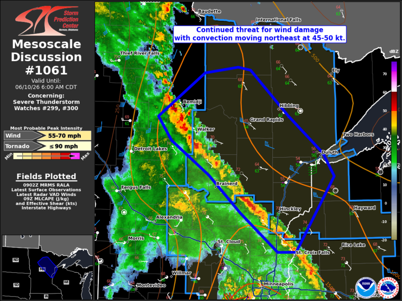
Mesoscale Discussion 1061 NWS Storm Prediction Center Norman OK 0404 AM CDT Wed Jun 10 2026 Areas affected...Central into northeast Minnesota...far northwest Wisconsin Concerning...Severe Thunderstorm Watch 299...300... Valid 100904Z - 101100Z The severe weather threat for Severe Thunderstorm Watch 299, 300 continues. SUMMARY...Wind damage remains possible from central into northeast Minnesota and far northwest Wisconsin early this morning. DISCUSSION...A line of convection continues to the northeast at around 45-50 kt. Given the speed of the line of storms, it would not take much convective augmentation to produce strong to marginally severe wind gusts even with the gradually decreasing moisture/buoyancy ahead of the activity. Damaging winds will remain a concern early this morning, though this threat may become more isolated with northeastward extent. ..Wendt.. 06/10/2026 ...Please see www.spc.noaa.gov for graphic product... ATTN...WFO...DLH...MPX...FGF... LAT...LON 47929441 47999375 47969349 47329274 46829206 46509183 45469261 45459296 45999369 46519433 46999507 47329535 47929441 MOST PROBABLE PEAK TORNADO INTENSITY...UP TO 90 MPH MOST PROBABLE PEAK WIND GUST...55-70 MPH |
|
|
Top/All Mesoscale Discussions/Forecast Products/Home |
|
Source link