|
|
| Mesoscale Discussion 1035 | |
| < Previous MD | |

|
|
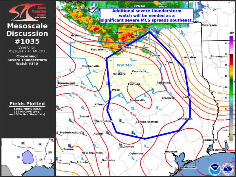
Mesoscale Discussion 1035 NWS Storm Prediction Center Norman OK 0610 AM CDT Tue May 28 2024 Areas affected...East TX Concerning...Severe Thunderstorm Watch 340... Valid 281110Z - 281245Z The severe weather threat for Severe Thunderstorm Watch 340 continues. SUMMARY...A significant severe MCS over the Metroplex will likely accelerate southeast across parts of east Texas through mid to late morning. Significant damaging gusts of 75-85 mph along with embedded severe hail will be possible. A new severe thunderstorm watch will be needed downstream of WW 340. DISCUSSION...A bowing complex is evolving across the Metroplex with ASOS-measured gusts to 77 mph at KDFW in the past 30 minutes. As mentioned in MCD 1033, this MCS will likely accelerate and move along the pronounced MLCAPE gradient that extends into southeast TX. Longer-term, this includes potential for the MCS to propagate to the northwest Gulf Coast later today. In the near-term, while the most intense severe gusts should persist within WW 340, it is plausible that damaging winds will spread farther east into parts of east TX and south into southeast TX. ..Grams.. 05/28/2024 ...Please see www.spc.noaa.gov for graphic product... ATTN...WFO...LCH...SHV...HGX...FWD...EWX... LAT...LON 33309584 32739517 32209465 31269448 30809449 30429487 30189601 30369695 31019727 31409717 32519732 33309584 |
|
|
Top/All Mesoscale Discussions/Forecast Products/Home |
|


