| Mesoscale Discussion 1019 | |
| < Previous MD | |

|
|
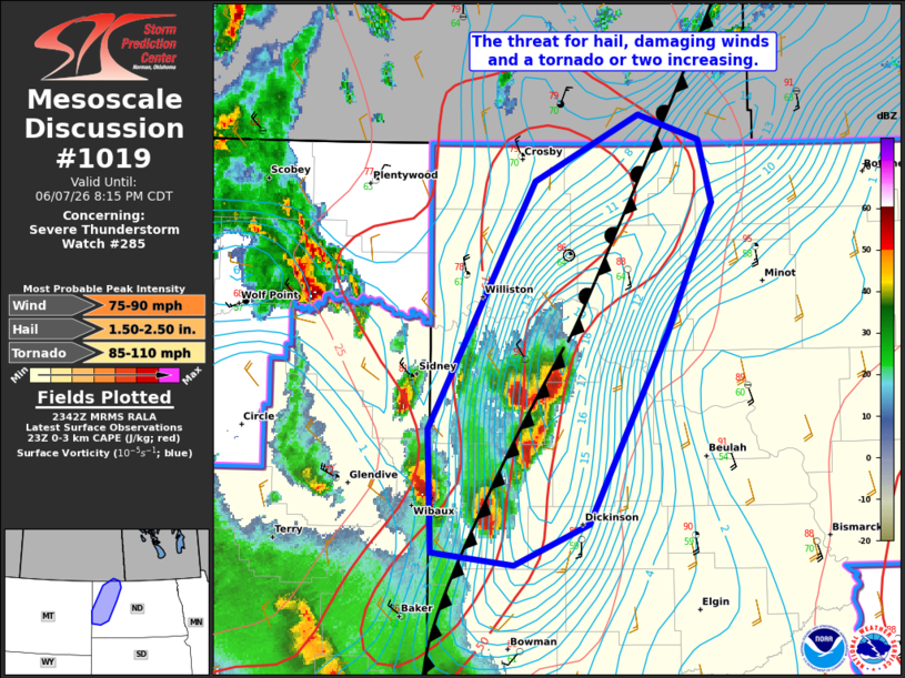
Mesoscale Discussion 1019 NWS Storm Prediction Center Norman OK 0645 PM CDT Sun Jun 07 2026 Areas affected...western North Dakota Concerning...Severe Thunderstorm Watch 285... Valid 072345Z - 080115Z The severe weather threat for Severe Thunderstorm Watch 285 continues. SUMMARY...Severe supercells along the cold front will pose a risk for hail, damaging winds and a tornado or two this evening. Eventually upscale growth into a line with a risk for significant damaging winds is possible. DISCUSSION...Several supercells have rapidly intensified along and behind the sagging cold front across northwestern ND. Richer low-level moisture (mid to upper 60s F surface dewpoints) along the cool side of the boundary is supporting large buoyancy amid strongly veering wind profiles. Hail (some greater than 2 inches) is likely with these initial supercells. Low-level moisture may also be sufficient for a couple of tornadoes given the strong low-level buoyancy and enhanced vertical vorticity along the front. Eventually the convection emanating out of MT and SD, as well as the surging front will favor upscale growth into linear clusters. The strong buoyancy and vertical shear would support a risk for damaging winds, some of which could be significant. ..Lyons.. 06/07/2026 ...Please see www.spc.noaa.gov for graphic product... ATTN...WFO...BIS...GGW... LAT...LON 46870272 46650335 46710402 47410406 48780317 49150231 49020181 48660171 47970206 46870272 MOST PROBABLE PEAK TORNADO INTENSITY...85-110 MPH MOST PROBABLE PEAK WIND GUST...75-90 MPH MOST PROBABLE PEAK HAIL SIZE...1.50-2.50 IN |
|
|
Top/All Mesoscale Discussions/Forecast Products/Home |
|
Source link