| Mesoscale Discussion 1006 | |
| < Previous MD | |

|
|
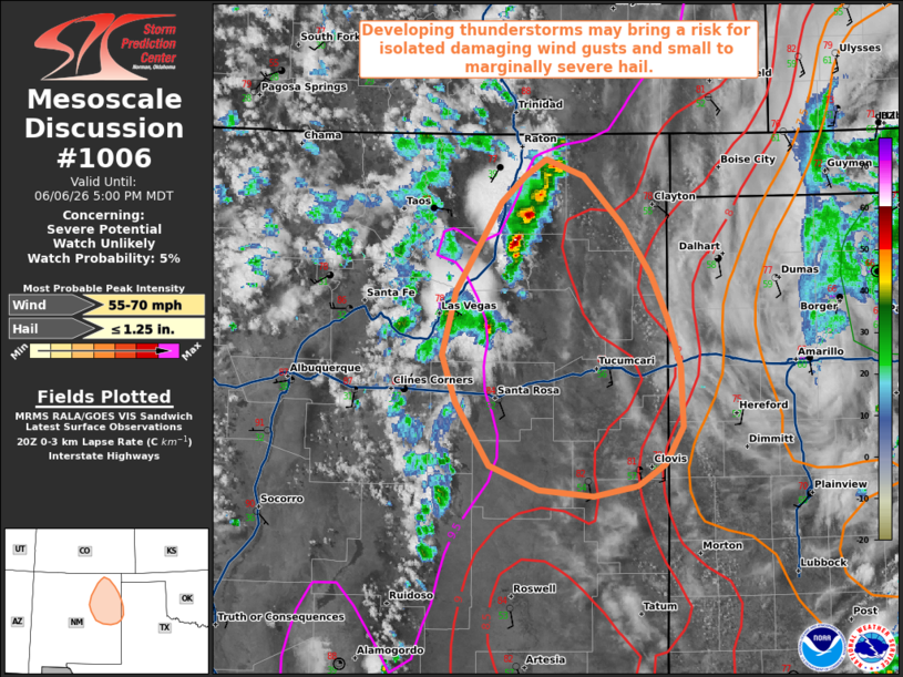
   Mesoscale Discussion 1006
   NWS Storm Prediction Center Norman OK
   0355 PM CDT Sat Jun 06 2026

   Areas affected...portions of northeastern/east-central New Mexico
   into the far western Texas Panhandle

   Concerning...Severe potential...Watch unlikely

   Valid 062055Z - 062300Z

   Probability of Watch Issuance...5 percent

   SUMMARY...Developing thunderstorms may bring a risk for isolated
   damaging to severe wind gusts and small to marginally severe hail
   through this afternoon/evening.

   DISCUSSION...Latest satellite/radar imagery depicts developing
   thunderstorms along the southern portions of the southern Sangre de
   Cristo Mountains in northeastern New Mexico. Continued diurnal
   heating of moist, southerly flow is supporting weak buoyancy
   (500-1000 J/kg), with well-mixed boundary layer profiles in place
   (steep low-level lapse rates and LCLs around 2000-2500 m per latest
   objective analysis). Enhanced northerly mid-level flow (30-40+ kts
   sampled at 3 km AGL by the FDX/AMA/LUB VWPs) on the western edge of
   a mid-level closed low/MCV is contributing to around 25-30 kts of
   effective shear. Coupled with a favorable environment for
   evaporative cooling, this may promote modest organization of a
   convective cluster along a developing cold pool. Latest guidance
   suggests such a cluster will evolve off of the mountains
   south-southeastward into east-central New Mexico and perhaps the far
   western Texas Panhandle through this afternoon/evening. Should this
   scenario occur, the primary threat would be isolated damaging to
   potentially severe wind gusts. An instance or two of marginally
   severe hail may also be possible, mainly with any more robust,
   initially discrete updrafts. Watch issuance is not anticipated at
   this time owing to the expected isolated nature of the severe risk.

   ..Chalmers/Thompson.. 06/06/2026

   ...Please see www.spc.noaa.gov for graphic product...

   ATTN...WFO...LUB...AMA...ABQ...

   LAT...LON   34890505 35260518 35770505 36460463 36670440 36790419
               36670384 36270345 35890319 35550303 35170292 34710289
               34420307 34240333 34160375 34210426 34410474 34890505

   MOST PROBABLE PEAK WIND GUST...55-70 MPH
   MOST PROBABLE PEAK HAIL SIZE...UP TO 1.25 IN
|
|
|
Top/All Mesoscale Discussions/Forecast Products/Home |
|
Source link