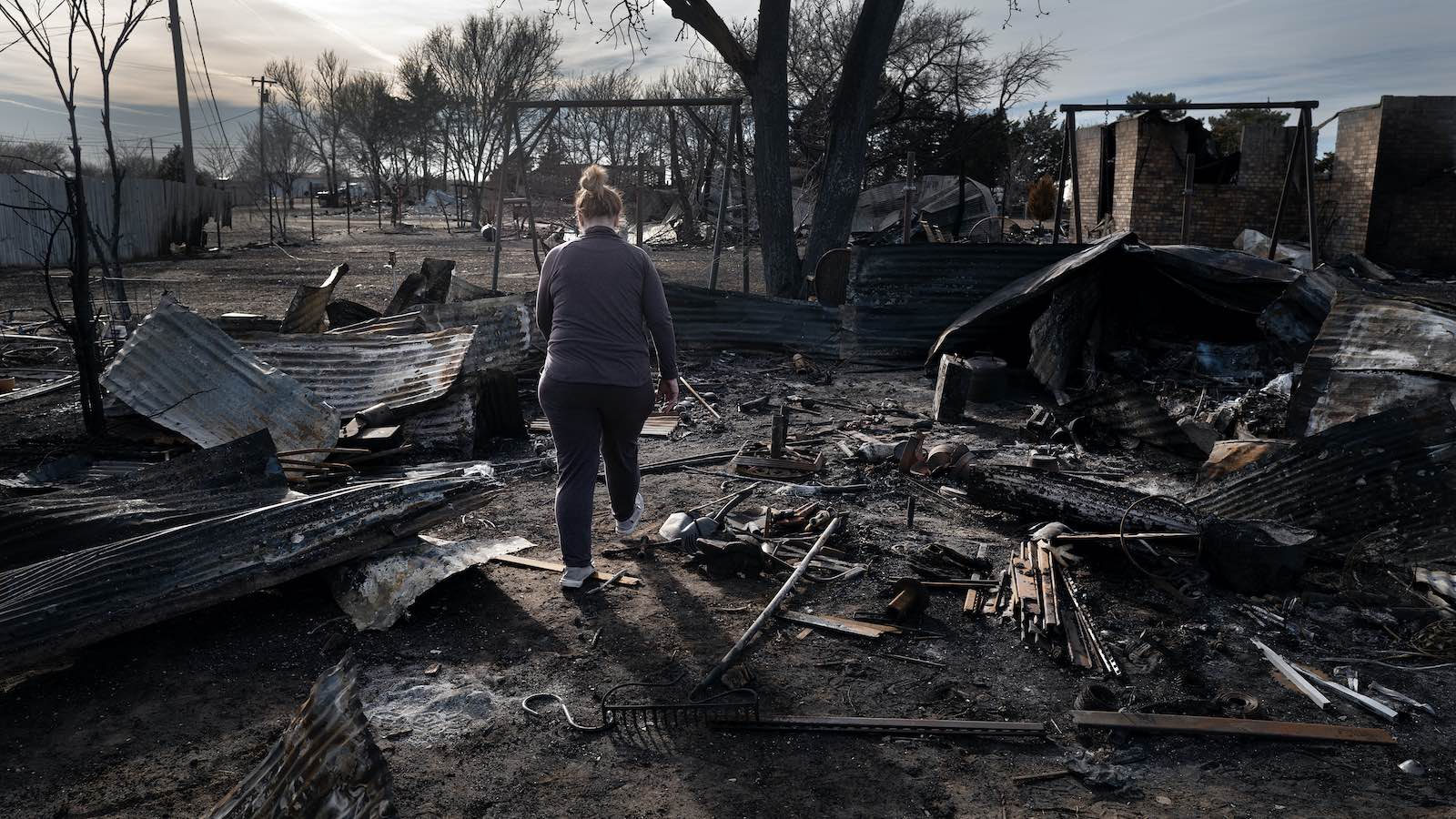
The biggest wildfire outside of Alaska in modern U.S. history recently tore a 100-mile-long, 20-mile-wide gash across the northeast Texas Panhandle and extreme western Oklahoma, destroying more than 500 structures and killing two people. Despite its horror, the fire served as a valuable test for a collaborative warning process that’s shaving precious minutes off the time needed to warn and evacuate residents.

The Smokehouse Creek Fire, which began on February 26, 2024, was declared fully contained on March 16 after burning 1,058,482 acres. A second fire just to the southwest, Windy Deuce, burned 144,045 acres. Both fires ranked as megafires (covering more than 100,000 acres), and both erupted after power lines were compromised by warm, dry winds gusting above 60 mph, according to the Texas A&M Forest Service.
Risk of large wildfires is growing in the Southern Plains

According to the 2023 Fifth National Climate Assessment, megafires across the Southern Plains — including the 16 recorded from 2000 to 2018 — “are associated with extremely dry vegetation, unusually warm temperatures, and strong winds aloft — conditions projected to become more prevalent as the region warms and soil water evaporates more quickly.”
Just a few days before the Smokehouse Creek Fire, wildfire experts from around the nation were meeting to discuss the new warning project and other emerging research on fire weather and forecasting. The workshop, held at the Norman-based National Weather Center, was sponsored by multiple entities from NOAA, the University of Oklahoma, and Oklahoma State University, including the NOAA-OU Cooperative Institute for Severe and High-Impact Weather Research and Operations. The meeting provided a glimpse of how experts in the Southern Plains — whose wildfire plague has gotten less national attention than the West’s — are developing some of the tools needed to address fire nationwide in tomorrow’s climate.
“While we know that large wildfires have been increasing substantially across forested regions of the western U.S. for some time, recent increases in large wildfire are relatively new in the Great Plains,” noted Victoria Donovan, an assistant professor of forest management at the University of Florida, in an interview with the USDA’s Working Lands for Wildfire.
The shift has been stark. According to Donovan, the Great Plains saw 33 documented large fires in the 10-year period from 1985 to 1994, but the rate jumped to 117 for the 10-year period 2005-2014.

Big state, big fire
Enormous “prairie fires” regularly coursed through the Great Plains for centuries before Europeans arrived. Such massive blazes had virtually disappeared by the mid-20th century. Fire suppression ruled, enforced in Texas mainly by local volunteers, and many small farms and highways served as natural firebreaks. Today, farming and ranching have been consolidated into larger operations, and many smaller acreages now serve as weekend retreats for landowners who prefer a natural — and perhaps more fire-prone — landscape.
In the 1990s, just as U.S. warming intensified, wildfire embarked on a devastating comeback across the Plains. Nowhere was the impact more dramatic than in Texas.
A 1996 fire northwest of Fort Worth consumed 65 houses and injured 52 people, part of record fire activity observed in all three Southern Plains states. Other startlingly large and intense fires followed. And in September 2011 — after a summer that was both the hottest and driest in state history — a catastrophic blaze fed by winds flowing toward Tropical Storm Lee consumed most of Bastrop State Park and neighboring pine forests east of Austin, taking two lives and destroying more than 1,600 homes and about 1.5 million trees.
“Something had changed,” fire expert Stephen Pyne observed in “The Great Plains: A Fire Survey. “A new Texas had morphed from the old, and fires ripped through it like monstrous tornadoes … A reliance on local volunteers could no longer cope with flames that blasted through communities, not just single dwellings, or surged over tens of thousands of acres, not vacant lots.”

New warning tools for wildfire
After a devastating sequence of Southern Plains fires in 2005-06, the Texas A&M Forest Service launched a major research program on fire behavior and prediction. Collaborations followed with Oklahoma and Kansas, which faced similar, newly aggressive fire threats. Since late 2005, the three states have experienced 38 Southern Great Plains wildfire outbreaks, which are defined as swarms of at least 10 fires that ignite on the same day and collectively burn at least 10,000 acres. This latest such outbreak (Feb. 26-27, 2024) included around 40 fires and torched more than 1.3 million acres.
All told, these outbreaks have killed 46 people and destroyed close to 4,000 structures across more than 8 million acres. The worst events are now on par with some of the region’s notorious severe weather outbreaks, says Todd Lindley, science and operations officer at the NOAA National Weather Service office in Norman.
Fighting physical fire with intellectual fire, Lindley and colleagues have been applying lessons learned through 75 years of severe weather forecasting in order to better anticipate and track firestorms.
Forecasters at the NOAA/National Weather Service Storm Prediction Center have long issued daily fire weather outlooks alongside outlooks for tornadoes and other types of severe weather, with risk levels ranging from “elevated” to “extremely critical.” Research is underway on new types of probabilistic guidance, including one showing the odds that a fire covering at least 5,000 acres might erupt in a given area.

Many of the tools long used to predict severe weather days in advance — including software from Saint Louis University that serves up analogues to past weather situations — are now illuminating the fire threat. For the most extreme outbreaks, “we learned that there is a predictable signal,” Lindley said at the workshop. In fact, twisters and blazes can strike in tandem: “We can have tornado warnings across the eastern part of our warning county area and red flag warnings and fire warnings to the west.”
Fire detection has also made great strides. The enhanced precision and versatility of the modernized NOAA GOES-R satellites that were launched in the 2010s allow for pinpoint sensing of incipient fires. Research after the 2019 Kincade Fire in northern California found that the fire could be discerned in shortwave infrared imagery from NOAA’s GOES-17 satellite a mere 52 seconds after ground-based infrared cameras indicated a fire had started.
“We’re able to see the flicker on the satellite immediately, and it jumps out on the map,” said National Weather Service senior forecaster and fire program coordinator Doug Weber in a news release.

National Weather Service offices in Oklahoma and California are now collaborating on ways to enhance such satellite-based fire detection, including its ability to penetrate cloud cover and get the word quickly to local officials. Lindley said up to 80% of such hot spot notifications in Oklahoma are reaching authorities ahead of local 911 calls.
When thousands of cellphones in the Texas Panhandle buzzed and beeped with fire warnings on February 26, it was because of the Integrated Team Fire Warning Paradigm Process, developed by a Southern Plains working group and tested over the past two years. This program involves National Weather Service forecasters alerting local officials when a fire appears on satellite. If the officials decide that conditions on the ground are concerning enough, they can then ask the National Weather Service to issue a warning and relay it to residents through the national phone-based Wireless Emergency Alert system. The polygon-shaped warning areas are similar to those used for tornadoes, severe thunderstorms, and flash floods.
“This entire process has been accomplished in nine minutes on average, ranging from three minutes to 15 minutes,” Lindley said in the news release. That’s a huge improvement from prior practice, where local emergency managers had to take the initiative to contact the National Weather Service and request that a warning be issued. That sequence could take up to 80 minutes.
The new system will be studied further at the NOAA/National Weather Service Fire Weather Testbed, which is to be launched this year in Boulder, Colorado.

The weather and climate that drive Southern Plains wildfire
Most parts of the United States aren’t fire-anxious in February, but across the Southern Plains, wildfires normally peak between February and April. So the Smokehouse Creek and Windy Deuce fires weren’t unusual in their seasonal timing. What does stand out, apart from their immense size, is that they formed during an El Niño winter. Many of the biggest Southern Plains fires occur during La Niña events, which tend to induce drought across the region.
In many settings around the globe, the worst firestorms occur after an unusually wet growing season that causes grasses and shrubs to proliferate and then dry out. That’s especially the case in the Southern Plains, where such fire-supportive fuel is far denser after wet years than after dry ones.
The growing season of 2023 was indeed wetter than average in the northeast Texas Panhandle. And wet conditions returned from December into February, which is typical for El Niño years. Yet it took only a few days of warm, dry weather in late February to flash-dry the landscape. Then came an intense storm system that swept into the Plains on February 26. Shrieking winds pushed springlike air far into the Midwest, where several cities, including Chicago, Des Moines, and Milwaukee, had their warmest winter day ever recorded.
Readings weren’t quite as extreme for the date in north Texas, but Amarillo set a daily record high of 82 degrees Fahrenheit. Combined with the high winds that broke power lines and the ample fuel on hand, it was more than enough to trigger a firestorm.
“It is surprising that we had a fire outbreak of this magnitude during an El Niño winter, but not unprecedented,” Lindley said in an email. “The 22-23 March 2016 Plains fire outbreak also occurred during El Niño. That one resulted in the Anderson Creek Fire, which was a megafire that burned from Oklahoma into Kansas.”

What happens when shrubs start hanging out with grasses
Not only are the Southern Plains vulnerable to the tendency for drought impacts to intensify in a warming climate, but the region’s landscape itself is becoming more fire-prone. Recent decades have seen an expansion of woody shrubs, including mesquite and red cedar. Though they’ve always found protective pockets in the landscape, their broader spread was limited for centuries by Indigenous use of fire. One study estimated that during preindustrial times, fire overspread most points on the Plains every 2 to 14 years. But by the late 20th century, decades of fire suppression coupled with changes in land use were allowing brush to expand across the Plains more widely than ever observed.
The largest of the Plains’ woody invaders can spew out crown-type flames that extend more than 300 feet downwind, hastening fire spread within grasslands. The Canadian River valley, where the Smokehouse Creek Fire raged, is laced with eastern red cedars and salt cedars as well as mesquite.
The University of Florida’s Victoria Donovan studied the evolving Plains fire threat while earning her doctorate at the University of Nebraska-Lincoln. In a 2010 paper, Donovan and colleagues analyzed how so-called woody encroachment affected the risk of large Great Plains fires from 1993 to 2014. Across all but one of the 14 Plains regions they studied, wildfire was most prevalent where woody vegetation predominated or coexisted with grasslands.
“We found that large wildfires were more likely to occur when woody vegetation comprised greater than 20% of the landscape, suggesting that relatively low levels of woody encroachment (~20% of the landscape) could be sufficient to increase large wildfire risk,” Donovan and colleagues reported.
The group, which did not analyze the specific role of climate change, concluded: “Future analyses could target areas and land-use types determined by our study to be highly impacted by wildfires with more nuanced assessments of the three major drivers of wildfire occurrence — fuels, climate, and ignitions — so we can better prepare for future change.”
The view from fire managers
Emergency managers are watching fire behavior change before their eyes. For her doctoral research at OU, assistant Oklahoma state climatologist Monica Mattox recently surveyed fire managers across the country. Among 264 federal, regional, and state fire managers who responded to her online survey, 31% were extremely concerned that climate change will increase wildfire threats, and more than 70% were at least somewhat concerned.
Climate change didn’t seem to loom as large among 20 local fire managers in Oklahoma who participated in five focus groups organized by Mattox. Although most of the participants said that wildfire risk was increasing, the concerns they expressed centered on the wildland-urban interface, increased exposure, fuel and land management, local staffing, and other on-the-ground issues. Only 10% said they thought climate change existed and was related to wildfire, while 20% did not think climate change existed at all, and the other 70% were more equivocal or said they didn’t know. “There’s a change, whatever you want to call it, there is a change in the traditional pattern,” one participant said.
Comments from yet another respondent touch on the challenge of dealing with more than one threat multiplier at the same time: “As population increases, the risk goes up. It’s just that simple.”
Jeff Masters contributed to this post.
We help millions of people understand climate change and what to do about it. Help us reach even more people like you.
Source link