Hurricane Ian carved a cruel path of destruction across the Florida Peninsula overnight, emerging over the Atlantic Ocean near Cape Canaveral as a large and wet tropical storm at 11 a.m. EDT Thursday. Along its path, Ian dumped record amounts of rain, including over two feet near New Smyrna Beach and over a foot in Orlando. The torrential rains triggered multiple flash flood emergencies and record river flooding.
Though greatly reduced in strength, the destructive hurricane is now headed for South Carolina, where landfall as a category 1 hurricane with 75 mph winds is expected to occur on Friday morning.
Record rains and flooding
After making landfall in southwest Florida at 3:05 p.m. EDT Wednesday, Ian gradually weakened as it moved across Florida at 8 – 9 mph. Ian maintained hurricane strength until 2 a.m. Thursday, when it was about 100 miles inland from its initial landfall point. At 5 a.m., Ian passed about 40 miles southeast of Orlando, by then weakened to a tropical storm with 65 mph winds.
Dry air on the south side of Ian’s circulation limited the amount of rain that fell to the right side of its track, but the hurricane’s intensity, large size, and relatively slow forward speed (30% slower than average) allowed it to dump prodigious amounts of rain along the left side of the track. Unusually warm waters near 29 degrees Celsius along Florida’s east coast – one degree Celsius (1.8°F) above average – contributed to the record rains. These two factors – higher sea surface temperatures and a slowdown in post-landfall movement of Atlantic storms in the United States – are among the multiple ways in which human-warmed atmosphere has been linked to hurricane behavior.


Orlando logged 12.49 inches of rain in the 24 hours ending at 8 a.m. EDT Thursday, causing heavy flooding near Kissimmee. This rainfall crushes Orlando’s previous 24-hour record of 9.67 inches set on Sept. 15-16, 1945. Rainfall records extend back to 1892 at Orlando.
The National Weather Service office in Melbourne, Florida, issued flash flood emergency warnings for three separate areas in east-central Florida on Thursday morning, including Daytona Beach and Sanford. Thirteen river gauges were at major flood stage on Thursday afternoon, and four rivers or creeks were at their highest flood stages on record. A CoCoRaHS site near New Smyrna Beach recorded an astounding 28.60 inches of rain in 27 hours.
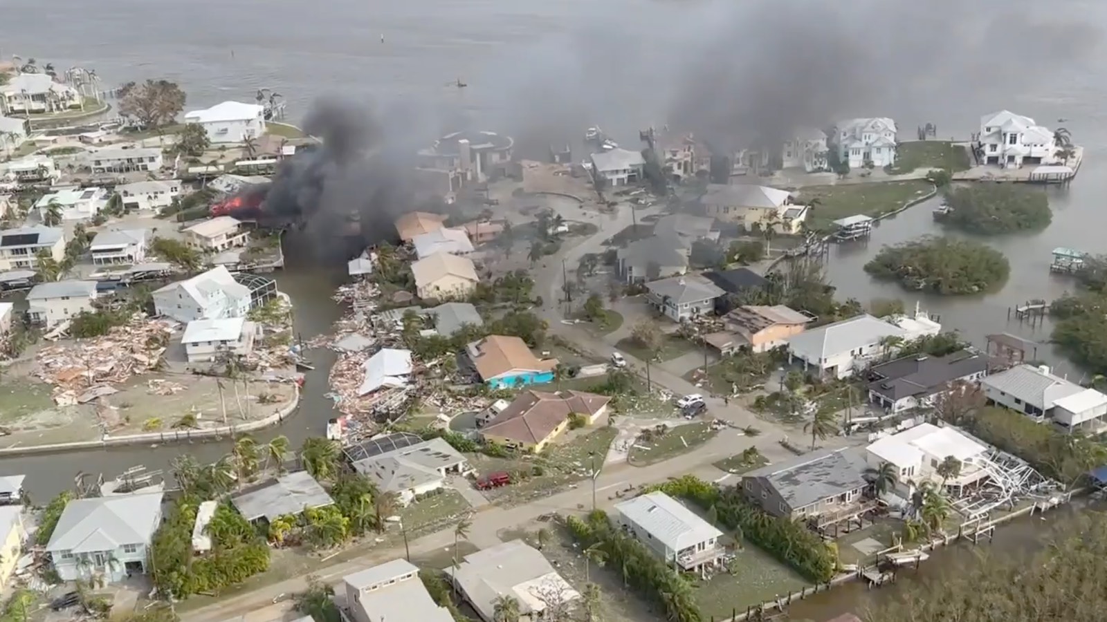
Ian’s surge produces massive devastation along coastal southwest Florida
It’s too soon for a comprehensive picture of the damage wreaked by Ian’s major surge, but given what we know already, it’s clear that many thousands of homes and businesses were damaged or destroyed. Catastrophic destruction occurred at Fort Myers Beach, where the bustling Times Square commercial district was in ruins. Similar outcomes can be expected over other islands that faced Ian’s wrath head-on, including Sanibel and Captiva, where reports were limited as of midday Friday. At least six deaths were being reported in Charlotte County by CNN on Thursday afternoon.
The storm surge at the Fort Myers tide gauge brought a water level that peaked at 7.25 feet Wednesday, smashing the previous record of 3.41 feet above mean higher high water (MHHW) set in Tropical Storm Keith (November 23, 1988). Records extend back to 1965. Before the tide gauge at Naples went out of service during the storm around 1 p.m. Wednesday, it recorded a peak water level above MHHW of 6.18 feet, far above the record since 1965 of 4.02 feet set in Hurricane Irma (September 10, 2017).
Apart from these gauge reports, the highest inundations on Wednesday from Fort Myers to Naples in some areas were likely as high as, or higher than, than those observed in Hurricane Donna in 1960, before complete records were kept. There were multiple reports of inundations from Donna of 8 to 12 feet in the Naples area and 7 to 11 feet in the Fort Myers area.
One big change is that the area had far fewer residents when Donna struck in 1960. The population of Lee County (which comprises the Cape Coral-Fort Myers metro area) has skyrocketed from 54,000 in 1960 to more than 750,000 today, and the population of Collier County (which comprises the Naples-Immokalee-Marco Island metro area) has soared from 15,000 in 1960 to more than 380,000 today. These numbers alone suggest that the damages from Ian will likely far exceed the impacts from Donna.
Ian knocks out power to over 2.6 million in Florida
As of 3 p.m. EDT on Thursday, September 29, Ian had knocked out power to over 2.6 million customers in Florida – approximately 24% of the state’s customers – according to poweroutage.us. In coastal Georgia, Ian’s winds were already beginning to topple trees and power lines on Thursday afternoon, with 8,000 customers without power at 3 p.m. EDT.
Forecast for Ian: A projected second U.S. landfall on Friday
Ian is on track to make a second U.S. landfall late Friday morning in South Carolina as the storm gradually arcs leftward. The models have been trending more to the east in recent runs, so a shift in the NHC forecast cone of uncertainty closer to North Carolina may occur. Ian will be rolling across the warm waters of the Gulf Stream, with sea surface temperatures near 29 degrees Celsius (84°F). Fierce wind shear of 25-30 knots – increasing to 35-40 knots overnight – will limit any redevelopment, but the National Hurricane Center predicts Ian will be a hurricane again by Thursday evening. A hurricane warning was in effect midday Thursday for the entire coast of South Carolina.
Ian will also be interacting with a broad frontal zone across the Southeast, so it could take on more characteristics of a midlatitude storm over time. The frontal zone will help increase onshore winds ahead of Ian, boosting its storm surge potential, as will the effect of the seasonal king tides. All these factors will lead to a damaging storm surge on Friday along the coast, from northeast Florida to North Carolina’s Outer Banks. Surge will generally be in the 2- to 6-foot range, but perhaps 4 to 7 feet near and just northeast of where Ian makes landfall. Ian no longer has an eyewall with a focused extreme wind maximum, so the exact location of landfall will not be a critical factor determining damage. Storm surge, wind, and flood damage from heavy rains will be spread out over a wide region along the Southeast U.S. coast.


The National Weather Service tidal gauge forecast at Fort Pulaski, Georgia, near Savannah, is predicting a crest of 10.9 feet with the midday-Friday high tide. This would be the third highest crest on record, topped only by 12.56 feet from Hurricane Matthew in 2016, and 12.24 feet from Irma in 2017. At the forecast peak, Tybee Island would experience widespread significant flooding and would be cut off from the mainland.
In South Carolina, Charleston Harbor is predicted to see a crest of 8.7 feet with the midday Friday high tide, which would rank among the ten highest crests on record there. The predicted crest of 8.9 feet at Myrtle Beach would be that location’s fifth highest on record – far below the 16 feet recorded during Hurricane Hugo in 1989, but still enough to produce widespread street flooding.
Ian’s corridor of extreme rainfall moved off the coast with the storm on Thursday afternoon. Lesser but still-impactful rains are expected to develop with the subsequent landfall, including 4 to 8 inches over South Carolina’s Lowcountry.
Website visitors can comment on “Eye on the Storm” posts (see comments policy below). Sign up to receive notices of new postings here.
Source link