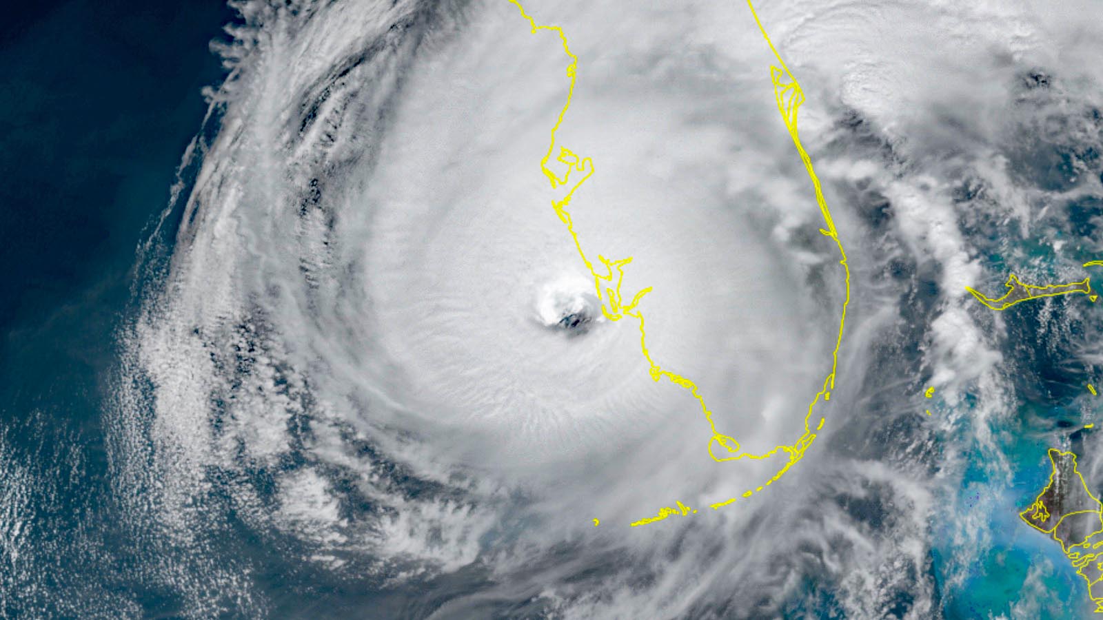
Hurricane Ian was powering ashore along the southwest Florida coast on Wednesday afternoon as a category 4 storm with 155-mph winds, which would make it the fifth-strongest hurricane on record to make a contiguous U.S. landfall, if it maintinas that intensity until the time of official landfall. The mighty hurricane’s winds, storm surge, and flooding rain are all expected to cause catastrophic damage, and Ian will go down in history as one of the most damaging hurricanes of all time.
A catastrophic storm surge aimed at southwest Florida
Ian was pushing a catastrophic storm surge along its right side into the southwest Florida coast as it charged ashore. Winds circulating around Ian pushed water offshore late Tuesday night, but the flow quickly switched to onshore Wednesday morning, triggering sharp rises in water. The storm surge will peak on Wednesday afternoon, with the timing of peak inundation modulated to some extent by the astronomical tides. Storm surge will continue well into Wednesday evening, as Ian pulls northward and southwest winds continue to funnel water into the southwest-facing coastline and bays.
Devastating and dangerous amounts of surge flooding can be expected, most likely including thousands of homes and businesses that have never before flooded. The storm surge is predicted to almost entirely submerge the barrier islands of Marco, Big Hickory, Estero, Captiva, North Captiva, Sanibel, Cayo Costa, Gasparilla, and Pine.
As of 2 p.m. EDT, the highest peak inundation levels predicted by the National Hurricane Center from Ian were centered on the Fort Myers area, including Charlotte Harbor, with the range as high as 12 to 18 feet from Englewood to Bonita Beach. Further south to Chokoloskee, including Naples, inundation of 8 to 12 feet is possible.
In official NOAA data extending back to 1965, the highest storm tides (storm surge together with astronomical tide) were 3.41 feet above mean higher high water (MHHW) in Fort Myers with Tropical Storm Keith (Nov. 23, 1988), and 4.02 feet above MHHW in Naples with Hurricane Irma (Sep. 10, 2017). Naples had already broken its record from Irma at midday Wednesday, with a water level of 6.18 feet, before its tidal station went out of service, and Fort Myers is virtually certain to break its own record later today.
The highest surge in Fort Myers could occur in the early to mid-afternoon as the astronomical tide is dropping from the afternoon high tide at 12:37 p.m. The average tidal range in Fort Myers is just 1.32 feet, so the timing of the surge here will not make a huge difference: A severe surge is expected regardless of tidal cycle. The next high tide will be at 6:45 p.m. Wednesday.
In Naples, the tidal range is higher (2.87 feet) so the timing of peak surge will make more of a difference to impacts. The highest water in Naples may occur within several hours of the 2:50 p.m. Wednesday high tide, but severe tidal impacts could well extend into the evening. The next low tide is at 8:42 p.m.
Storm surge flooding in southwest Florida from Ian will transcend anything observed in the last few decades, perhaps challenging or even topping the living-memory records set during Hurricane Donna in 1960. Donna carried out a looping path, cutting across the Bahamas and Florida Strait, moving across the Keys at category 4 strength, and then arcing northward close to Naples and Fort Myers as a category 3 storm before angling northeast on a devastating course along the U.S. East Coast. This was a substantially less favorable track for surge production than Ian’s, yet there were multiple reports of inundations from Donna of 8 to 12 feet in the Naples area and 7 to 11 feet in the Fort Myers area. The region now has about four times more people than it did in 1960, which greatly raises the potential for catastrophic damage.
On Tuesday night, Ian passed about 75 miles to the west of Key West, and generated the third-greatest surge on record there: 2.46 feet above MHHW, which caused major flooding near the time of the 11:30 pm. EDT high tide. The only higher water levels observed at Key West were during Hurricane Wilma in 2005 (3.14 feet) and Irma in 2017 (2.66 feet). Third place was previously held by Hurricane Betsy of 1965 (1.93 feet). Records extend back to 1913 at the station.
Tampa Bay, which initially was predicted to receive a devastating 5 – 10 feet of storm surge if Ian had made landfall to its north, has instead seen a negative storm surge today, since Ian’s landfall came to the south. Because of the counter-clockwise circulation of air around Ian, strong offshore winds reduced the level of the Tampa Bay by over four feet on Wednesday afternoon. Once Ian progresses north of Tampa Bay on Thursday, bringing onshore winds, a positive surge will replace the negative surge. As of the 2 p.m. EDT Wednesday NHC advisory, a surge of 4 – 6 feet was predicted for Tampa Bay.
Ian’s large wind field increases its damage potential
While a hurricane’s maximum winds at landfall are important for determining the destructiveness of its storm surge, the size of hurricane, its forward speed, and angle of approach to the coast are also important. Hurricane Charley was a high-end category 4 hurricane with 150 mph winds at landfall, yet it brought a peak storm surge of 6 – 7 feet to the coast at the same location where Ian (with 155 mph winds) is predicted to bring a storm surge of 12 – 18 feet.
Part of the difference lies in the forward speed of the two hurricanes. Charley was moving at 20 mph at landfall, and it didn’t have as much time to pile up a big storm surge as Ian, which was moving at 9 mph.
But a more important factor is the size of the storm. Lat Tuesday, Ian underwent an eyewall replacement cycle in which the inner eyewall collapsed and was replaced by an outer eyewall of larger diameter. This process, common in intense hurricanes, spreads out the hurricane’s winds over a larger area. Ian was able to put a large area of ocean into motion and generate a much larger storm surge than Charley did. Thus, the the usual Category 1-5 Saffir-Simpson scale is inadequate for describing storm surge risk – which is why NHC in recent years has been issuing separate storm surge warnings and hurricane warnings.
A better way to estimate storm surge damage potential is to compute the total energy of a hurricane’s surface winds (kinetic energy). To do this, we must look at how strong the winds are, and factor in the areal coverage of these winds. So the integrated kinetic energy, or IKE, is computed by squaring the velocity of the wind and summing over all regions of the hurricane with tropical storm force winds or higher. The IKE concept was published by Dr. Mark Powell of NOAA’s Hurricane Research Division in 2007, and is now used by RMS.com. They gave Hurricane Ian an IKE index of 47 terrajoules this morning, nearly seven times higher than the 7 terrajoules Hurricane Charley of 2004 had.
Here is a list of some IKE values computed for hurricanes as landfall, according to RMS.com and Brian McNoldy:
Isabel (2003): 173
Sandy (2012): 141
Katrina (2005): 121
Opal (1995): 120
Wilma (2005): 103
Hugo (1985): 94
Frances (2004): 93
Ivan (2004): 81
Florence (2018): 49
Ian (2022): 47
Ida (2021): 47
Dennis (2005): 40
Laura (2020): 21
Andrew (1992): 20
Charley (2004): 7
The ultimate storm surge impact depends not only on IKE but on the geographic particulars of the coastline affected by landfall, and of course on the amount of development present. In addition, note that sea level along the southwest Florida coast is about a foot higher than is was 100 years ago, because of sea-level rise from human-caused climate change. This extra foot of sea level will substantially increase the storm surge damage from Ian.


Ian beyond landfall: A destructive path ahead from southwest to northeast Florida, and another landfall possible in Georgia/South Carolina
Ian’s rampage will extend well beyond southwest Florida. By Thursday morning, Ian is still projected to be near hurricane strength as it passes over or near the Orlando area. Along the way, and particularly in heavily populated Orlando, Ian will bring down trees and knock out power to many thousands of people, much as Hurricane Irma did on its south-to-north course through the state in 2017. As of 3 p.m. EDT Wednesday, Ian had already knocked out power to nearly 800,000 customers in Florida, according to poweroutage.us.
Ian is expected to move off Florida’s East Coast by Thursday afternoon, still as a tropical storm, then angle back to the northwest, likely making a second landfall somewhere in Georgia or South Carolina on Friday afternoon. Hurricane warnings were in effect Wednesday afternoon in and around Florida’s Space Coast, from Sebastian Inlet to the Flagler/Volusia County Line. Tropical storm warnings are already in place further north, encompassing the northeast Florida coast and the entire coastline of Georgia and South Carolina. Ian will be passing over the Gulf Stream during its trek of about 24 hours over the Atlantic. Despite the influence of high wind shear and dry air, Ian may be able to hold its own while offshore, taking advantage of warm sea-surface temperatures and an upper-level jet streak that may provide outflow toward the north.
It’s too soon to be too specific about Ian’s strength by Friday, but a tropical storm landfall is certainly possible, and a significant storm surge may result from Ian’s circulation combined with the seasonal king tides now under way. The National Weather Service tide-gauge forecast for Charleston Harbor, South Carolina, projects major flooding of 8.6 feet with the high tide around midday Friday. That would be the among the 10 highest crests on record, only about a foot below the Irma peak of 9.92 feet on Sept. 11, 2017. The Savannah River at Fort Pulaski, Georgia, is predicted to reach 10.8 feet at midday Friday, which would be the fourth highest crest in records going back more than 80 years. At a crest of 10.5 feet, according to the NWS, “Damaging flooding is expected, expanding along the entire southeast Georgia coast. Flooding will likely cause the closure of HW-80, isolating residents on Tybee Island. Several other island communities will also likely become isolated due to flooded and impassable roadways. On Tybee Island, widespread significant flooding is expected with numerous properties impacted.”


Historic rainfall in store for parts of Florida
Titanic amounts of rain are expected across a broad corridor running along and just north of Ian’s path, roughly from the Tampa-to-Fort Myers area northeastward to Jacksonville-Melbourne. Within this corridor, widespread totals of 10 – 15 inches of rain can be expected, with pockets of 15 – 20 inches possible, including near Orlando. These amounts may rival or exceed the heaviest three-day totals ever recorded in several major Florida cities, as suggested by the records below.
Tampa: 14.57 inches (July 28-30, 1960; records go back to 1890)
Orlando: 13.75 inches (Oct. 16-18, 1950; records go back to 1892)
Jacksonville: 14.43 inches (Aug. 28-30, 1968; records go back to 1871)
“Widespread, life-threatening catastrophic flash, urban, and river flooding is expected across central Florida,” warned the NWS. Multiple rivers in western Florida are predicted to rise to record levels on Friday, including the Myakka and Peace.
Enhanced tornado threat with Ian in Florida
The NOAA/NWS Storm Prediction Center (SPC) catalogued 10 tornadoes from Tuesday into Wednesday morning, associated with intense thunderstorms from Monroe to Palm Beach Counties on the far east and northeast edge of Ian’s influence. Delray Beach and Boynton Beach were among the communities affected. Several aircraft were flipped over by an apparent tornado at North Perry Airport in Pembroke Pines.
Landfalling hurricanes often spawn tornadoes, especially toward their front right quadrants, and Ian may be an overachiever. SPC issued an enhanced risk area (the third highest of its five risk categories) for east central Florida for Wednesday, including the Space Coast area. Increasing wind shear and mid-level dry air will help lead to an environment that supports supercell-type structures within the thunderstorms ahead of Ian’s path. Hurricane Ivan was the most prolific tornado-producing tropical cyclone on record, leading to seven tornado-related deaths and generating 120 twisters from September 15 to 18, 2004, mainly in Florida.
“While not overly common in tropical cyclone-related situations, a strong (EF2+) tornado could occur, particularly across the east-central Florida Peninsula,” warned SPC.
A wild ride for the Hurricane Hunters
On Tuesday morning, an Air Force hurricane hunter aircraft penetrated the eyewall of Ian and encountered severe turbulence. A powerful updraft hurled the plane 700 feet higher in the air, followed by a downdraft that made the plane plunge up to 1,200 feet. The aircraft also encountered hail that stripped black paint from its nose (see images in Tweet below). The aircraft likely hit a tornado-scale mesovortex in the eyewall, akin to what Jeff Masters encountered during his near-fatal encounter with Hurricane Hugo in 1989. Fortunately, today’s flight was performed at 10,000 feet – much higher than the 1,500-foot altitude the Hugo flight was done at.
Website visitors can comment on “Eye on the Storm” posts (see comments policy below). Sign up to receive notices of new postings here.
Source link