Hurricane warnings were extended southward along Florida’s southern Gulf Coast late Tuesday afternoon, encompassing the Naples area and Marco Island, as category 3 Hurricane Ian steadily intensified. An eastward jog in Ian’s track on Tuesday has resulted in some major shifts in where and when Ian could make landfall. Regardless of its landfall point, Ian will bring destructive hurricane impacts to large parts of Florida, including torrential rains and flooding, dangerous storm surge, and high winds.
As of Tuesday evening, hurricane warnings extended from the Anclote River near Tarpon Springs, north of Tampa, south to Chokolosee, on the west edge of the Everglades. This unusually large warning area is even broader than the “cone of uncertainty,” a sign of how the coastal geometry combined with Ian’s track makes this landfall forecast especially challenging.
It’s worth noting that the cone is based on the historical track errors for each tropical cyclone over the preceding five years, and the width of the cone is set such that hurricanes can be expected to stray outside the cone about one-third of the time. The cone is not designed to show when there is a unusually high level of uncertainty with a particular storm’s landfall location, as is the case with Ian.


The intensity outlook through landfall
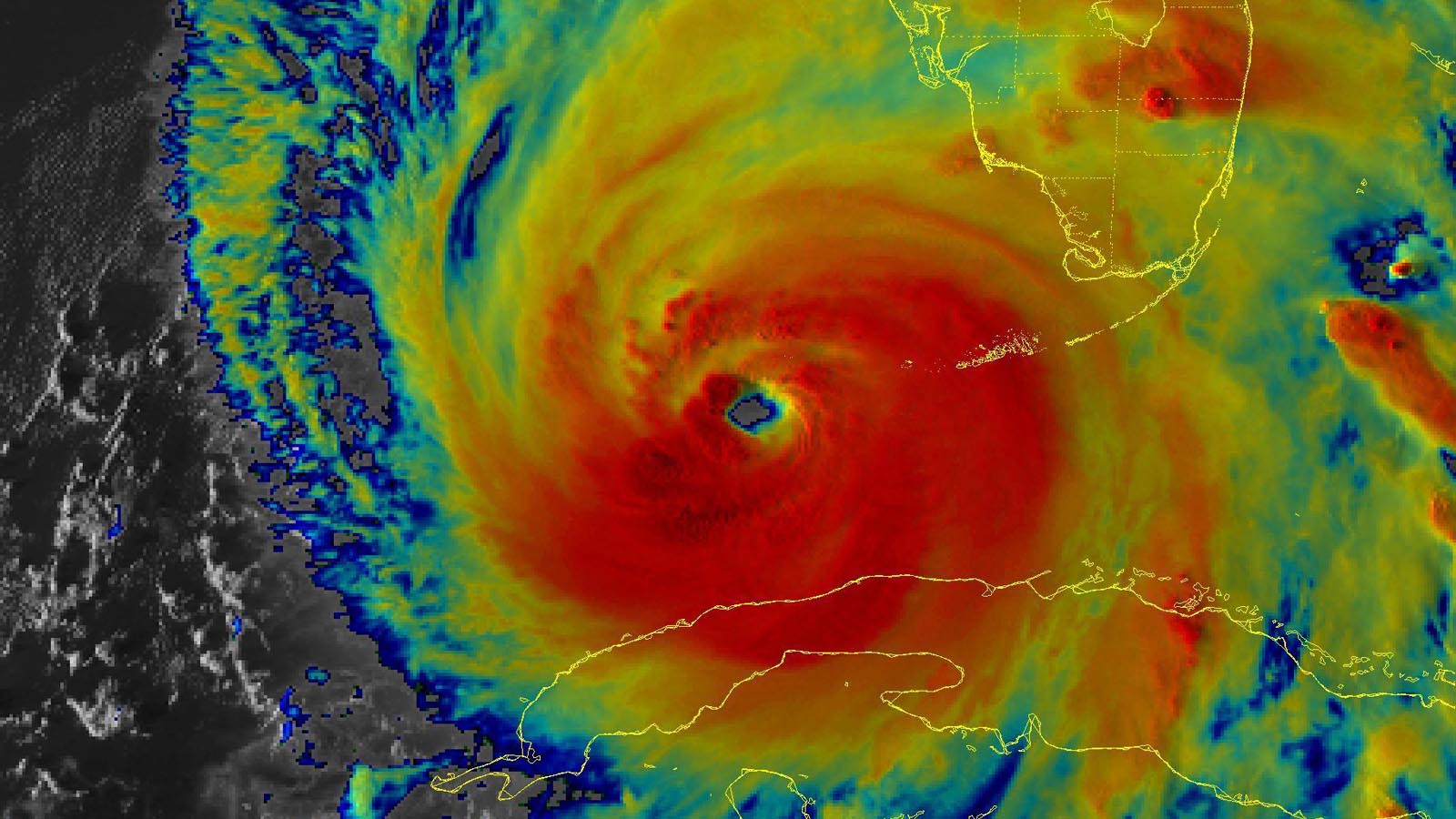
Ian was packing top sustained winds of 120 mph as of 8 p.m. Tuesday. Reconnaissance aircraft found that its central pressure had dropped to 947 millibars. Aircraft and radar observations on Tuesday evening showed that Ian appeared to be undergoing an eyewall replacement cycle (ERC), with an outer eyewall of larger diameter competing with the inner eyewall for dominance. The end result of this process is likely to be that the inner eyewall collapses, the peak winds of the hurricane decrease, and the area covered by hurricane-force winds expands, thereby increasing the storm surge potential of the hurricane.
Once the ERC is complete (which can take up to a day, although Tuesday night’s ERC was proceeding quickly), Ian is likely to resume intensifying. With Ian experiencing a high 20-30 knots of wind shear on Tuesday evening, it is possible that the high wind shear will be able to breach the eyewall during the ERC and significantly weaken the hurricane. However, the current National Hurricane Center forecast and top intensity models depict no such event occurring, and there are no indications at this time that Ian will significantly weaken before landfall.
As of 5 p.m. Tuesday, NHC was predicting that Ian’s sustained winds would reach 130 mph – the bottom end of the category 4 range – and remain there until Ian nears the Florida coast on Tuesday afternoon.
As discussed above, increasing wind shear, drier air, and the ERC under way could trim Ian’s top winds by landfall. However, Ian’s water-related impacts, including rainfall, will be largely baked into the storm by that point. In addition, tropical-storm-force winds could extend inland to the Orlando area and beyond, so widespread tree damage and power outages are likely across much of the state.
Dangerous storm surge to affect broad stretch of coastline
A large stretch of heavily developed Florida coast, from Sarasota to Fort Myers, will potentially receive a highly destructive storm surge from the right-front quadrant of Ian.
One area of high concern is Punta Gorda and Port Charlotte, which lie on Charlotte Harbor. This portion of the coast is forecast to receive 8 – 12 feet of storm surge, which would be the most in modern records and considerably more than during the landfall of category 4 Hurricane Charley (see below). Unfortunately, the two rivers flowing into Charlotte Harbor, the Peace and Myakka, are already at minor flood stage from heavy rains earlier in the month. The heavy rains from Ian will increase the flooding of these rivers, causing a compound flood event in Charlotte Harbor that will boost the storm surge damage to Punta Gorda and Port Charlotte. A surge of 6 – 9 feet is predicted in the Naples area. Surge forecasts in the Tampa Bay area have been lowered to the 4 – 6 foot range.
Much of southwest Florida was experiencing northeast winds blowing offshore on Tuesday evening, bringing coastal water levels below average. As Ian approaches on Wednesday, water levels will rise dramatically along the coast from south to north.
Storm surge flooding this week will be augmented by some of the highest tides of the month, the “king tides,” occurring because of the new moon on Sunday. Tidal range between high and low tide is about 2 – 2.5 feet at Tampa, and the highest tides this week are between 3 – 5 a.m. EDT Wednesday through Saturday. At Fort Myers, the tidal range is just over one foot this week, so the timing of Ian’s surge with respect to the tidal cycle is less important than for Tampa Bay.
A large and powerful hurricane, Ian has a counter-clockwise circulation that will also create destructive storm surge flooding on the east coast of Florida, and northward along the Georgia and South Carolina coasts. This storm surge flooding will also be augmented by the king tides. There is also a possibility that Ian itself will move off the northeast Florida coast into the Atlantic around Friday – most likely a tropical storm by this point – and then make a second landfall in Georgia or South Carolina, worsening rainfall and coastal flooding threats there.


Ian’s rains expected to produce catastrophic flooding
The flood hazard from Ian will extend well inland and well beyond landfall, as the hurricane is projected to dump immense amounts of rains along a southwest-to-northeast corridor from the Gulf to the Atlantic, likely including Tampa and Orlando. Storm-total rainfall predicted by the National Weather Service Weather Prediction Center as of Wednesday afternoon has been increased to 15-20 inches along the corridor roughly 50 to 100 miles wide along and just north of Ian’s path. Pockets of especially intense rains could produce storm totals of more than 25 inches.
“Widespread catastrophic flash, urban, and river flooding is expected across central and west Florida beginning midweek,” warned NHC in its 5 p.m. Tuesday advisory on Ian. Additional rain-induced flooding is expected from northern Florida to coastal Georgia and South Carolina later this week and into the weekend as Ian works it way northeastward.
Both Tampa and Orlando could get unprecedented multi-day rainfall amounts from Ian. The heaviest three-day totals ever recorded in observations going back to 1890 in Tampa and 1892 in Orlando are 14.57 inches in Tampa (July 28-30, 1960) and 13.75 inches in Orlando (October 16-18, 1950).


Comparing Hurricane Ian to Hurricane Charley (2004)
As shown in Figure 3 above, there are some striking similarities between Hurricane Ian and Hurricane Charley in 2004, and also some key differences. On August 13, 2004, Hurricane Charley made landfall on the coast of Florida at Cayo Costa Island, just north of Captiva. At landfall, Charley was a category 4 storm, with 150-mph winds and a central pressure of 941 mb. Charley’s eye passed over Punta Gorda, and the hurricane’s eyewall hit Port Charlotte, causing the severe wind damage that was Charley’s most destructive aspect.
Charley was a very small hurricane, its eye was very tight, and the extreme eyewall winds extended out only about 7 miles from the center. Shortly before landfall, hurricane-force winds extended out 30 miles from Charley’s center, and tropical storm-force winds, 105 miles. For comparison, at landfall, Ian is predicted to have hurricane-force winds extending 45 miles from the center, and tropical storm-force winds out to 185 miles.
Charley moved at a rapid 20 mph at landfall and accelerated as it moved inland over Florida. This rapid motion allowed it to reach Orlando, located over 130 miles inland, with sustained winds of hurricane force (79 mph, gusting to 105 mph). Because of Charley’s small size and rapid forward speed, it was not a big rain-producer, and caused little fresh-water flood damage: Maximum rainfall totals from gauges in Florida topped out a little over 5 inches, though radar-estimated storm precipitation over central Florida was as high as 6 – 8 inches. For comparison, Ian is predicted to be moving near 6 mph at landfall, and produce widespread 15-20 inches of rain well inland, with even higher isolated amounts, causing catastrophic flooding.
Because of its rapid forward speed and small size, Charley produced a very modest storm surge for a Cat 4. The highest surges measured at tide gauges were 4.2 feet near Fort Myers Beach, and 3.4 – 3.6 feet on the Caloosahatchee River, near Fort Myers. There were visual estimates of storm surges of 6 – 7 feet on Sanibel and Estero Islands. Even though Ian’s maximum winds are predicted to be lower than Charley’s, Ian is projected to bring a much larger surge: a maximum storm surge of 8 – 12 feet is predicted. This larger surge will occur because of Ian’s larger size and slower motion, which allows a bigger surge to pile up.
Charley killed 35 people (15 direct deaths) and did $25 billion in damage, making it the 14th-most expensive U.S. hurricane on record. Ian is likely to have a price tag rivalling or exceeding that, since the hurricane’s storm surge and inland flood damage will be much greater than Charley’s.
Website visitors can comment on “Eye on the Storm” posts (see comments policy below). Sign up to receive notices of new postings here.
Source link