The last chapter of the violent and merciless rampage of Hurricane Ian is finally drawing to a close over the Mid-Atlantic and Central Appalachians, where the remnants of the powerful storm were still dumping heavy rains and bringing rough seas to the coastal waters on Saturday afternoon. Ian’s three destructive landfalls brought tremendous death, destruction, and suffering, ensuring that the name Ian will never again be used for an Atlantic storm.
While the death and damage tolls will remain fluid over the next few days, weather.com was reporting at least 46 deaths related to Ian in eight Florida counties, with 3 deaths in Cuba. The final U.S. death toll may approach the number from last year’s Hurricane Ida, which took 87 lives, most from flooding in the Northeast long after landfall. In 2017, Hurricane Irma took 92 U.S. lives and Hurricane Maria caused thousands of deaths in the U.S. territory of Puerto Rico (the official estimate is 2,975 lives lost). Insured plus uninsured U.S. losses from Ian could be between $50 and $100 billion (see Friday post).
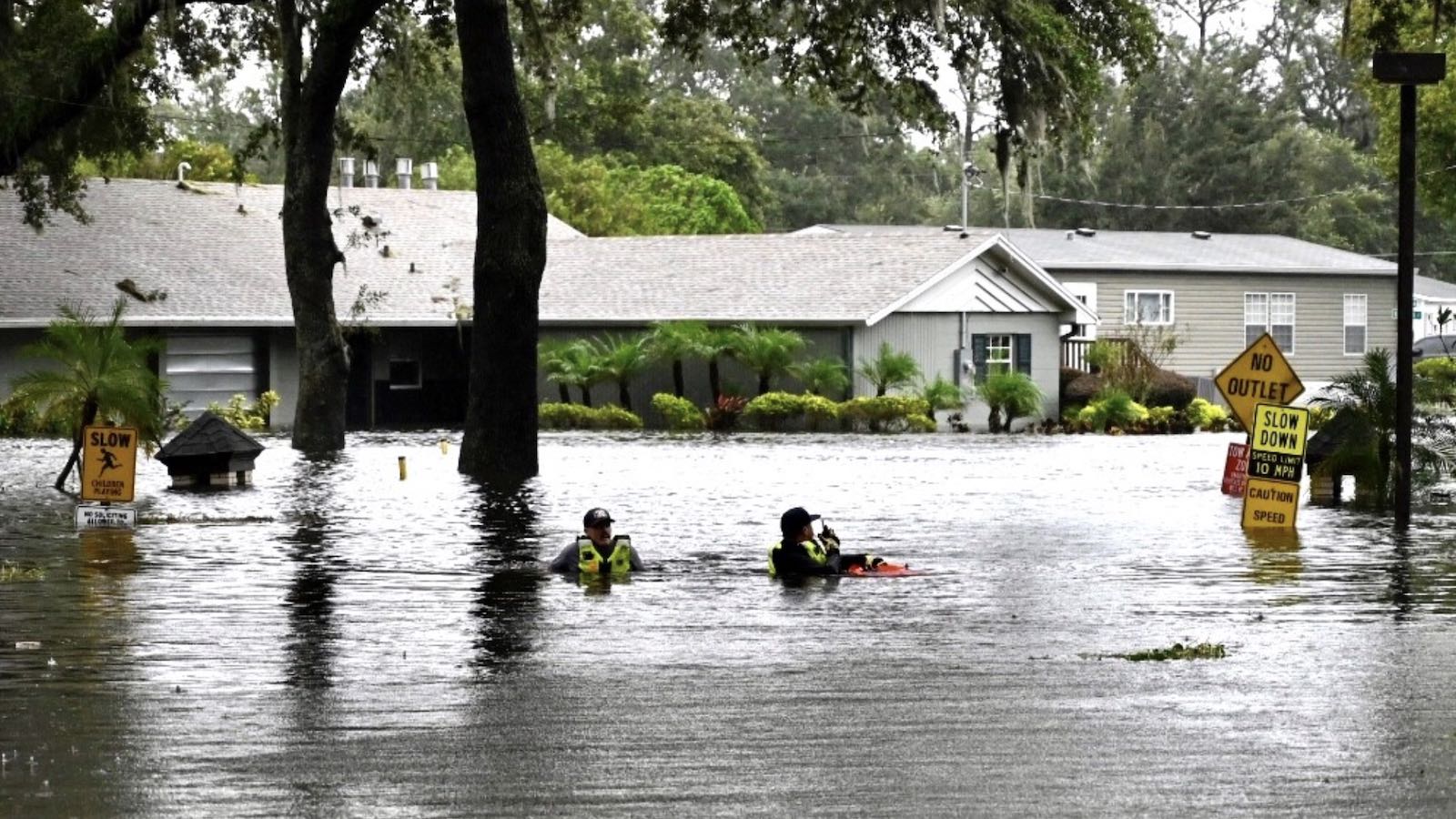
Ian’s destruction has not been fully realized yet, since destructive river flooding continues in Florida, where major flooding was reported at 11 river gauges on Saturday. Flooding on the Myakka River forced a 14-mile stretch of Interstate 75 to close between Sarasota and Port Charlotte Friday night. The river reached an all-time record height on Friday, and is forecast to remain above the major flood threshold through Tuesday.
Power out to 1.2 million in Florida, 270,000 in Carolinas, and much of western Cuba
As of 12 p.m. EDT on Saturday, October 1, Ian had knocked out power to some 1.2 million customers in Florida (about 11% of the state’s customers), down from a peak of 2.7 million on Thursday, according to poweroutage.us. In North Carolina, 294,000 customers were without power, as were 78,000 in Virginia and 48,000 in South Carolina.
In Cuba, where Ian had caused an island-wide blackout on Tuesday, the power was still out Friday night in much of the capital of Havana, where a second night of widespread street protests in frustration over the blackout erupted, according to Aljazeera. Officials said on Friday that power had been restored to about 60% of Havana’s two million people. Ian had hit western Cuba on Tuesday as a category 3 hurricane with 125 mph winds, killing two people.
Meanwhile, in Puerto Rico, which had suffered an island-wide power outage on September 19 because of Hurricane Fiona, the power was still out to 210,000 customers on Saturday, about 14% of the island’s customers. The operator of Puerto Rico’s electrical grid, Luma Energy, said that damage to the grid from Fiona might reach $1 billion. Fiona is being blamed for 21 direct and indirect deaths in Puerto Rico. Total damages in Puerto Rico from the hurricane have not yet been quantified.
In Canada’s Nova Scotia province, where Fiona made landfall September 24 as a powerful category 2-strength extratropical storm, about 60,000 customers were without power on Friday, down from about 78,000 Thursday. Fiona’s insured damage in Canada has been estimated at about $200 – $500 million USD.
Please donate to help hurricane victims
To help out with Hurricane Ian or Hurricane Fiona recovery efforts, please consider donating to one of these worthy causes:
The Partnership for Inclusive Disaster Strategies (Formerly Portlight.org), helping disabled people recover from the hurricanes.


Hurricane Orlene headed for Mexico’s Pacific Coast
The next North American landfall from a tropical cyclone will likely be category 1 Hurricane Orlene, moving northward toward Mexico’s Pacific Coast on Saturday. Hurricane warnings were hoisted for Las Islas Marias as Orlene was upgraded to hurricane status at 11 a.m. EDT Saturday. Orlene had top sustained winds of 75 mph and was headed north at about 5 mph.
Southerly steering currents should keep Orlene moving generally north to north-northwest over the next couple of days. On its current forecast track, Orlene will reach the coast somewhere in the vicinity of Mazatlan on Monday. Along the way, Orlene will benefit from very warm sea-surface temperatures (28-30 degrees Celsius or 82-86 degrees Fahrenheit) and a relatively moist atmosphere (mid-level relative humidity from 60 to 70 percent), and it’s possible the hurricane could reach category 2 strength by Sunday. However, wind shear will increase sharply beginning later Sunday, and this should trim Orlene’s strength before it makes landfall on Monday, most likely as a tropical storm.
Orlene could bring widespread 3-5″ rains and localized totals of up to 10″ as it moves inland, bringing the risk of flash floods and mudslides.


A new system increasingly likely to develop in eastern Atlantic
A disturbance still not yet classified as an “invest” is moving through the eastern tropical Atlantic, with growing odds of developing in the next several days as it drifts generally west to west-northwest. The broad disturbance was at low latitudes in the eastern tropical Atlantic on Saturday, centered near 25 degrees west longitude (see Figure 2 above). Showers and thunderstorms remained disorganized but were slightly more active than on Friday.
The new disturbance will be moving through a moist mid-level environment free of intense wind shear or a pronounced Saharan Air Layer, atop sea surface temperatures (SSTs) around 28 degrees Celsius (82 degrees Fahrenheit). A large number of Friday night’s ensemble runs of the GFS and European models show a tropical depression forming by early next week. A break in the subtropical ridge of high pressure should allow the incipient system to angle northward during the week.
In its Tropical Weather Outlook issued at 2 p.m. EDT Saturday, the National Hurricane Center gave the system a 20 percent chance of developing into at least a tropical depression by Monday afternoon and a 70 percent chance by Thursday. The next name on the Atlantic list is Julia.
Another westward-moving tropical wave in the central tropical Atlantic was not mentioned by NHC in their 8 a.m. Tropical Weather Outlook but has some support for development in about a week by the GFS and European ensemble models.
When can we put this season to bed?
The tropical Atlantic reminded us this week – painfully – that the 2022 hurricane season is far from over. A typical Atlantic season (based on 1991-2020 climatology) will produce four of its 14 annual storms and two of its 7 hurricanes after September 30.


Moving into October, the focus will shift toward storms that develop in the Caribbean and move north or northeast. Cold fronts penetrating increasingly far south will limit the opportunities for tropical and subtropical development in the Gulf of Mexico and the open Northwest Atlantic, and the Cabo Verde waves that typically stream off Africa in August and September will become more infrequent. This year, nearly all of the Cabo Verde waves struggled mightily with wind shear and/or dry air, for reasons not yet fully clear. This pattern may not occur over the Caribbean in October.
The latest two-week outlook from Colorado State University, issued on Thursday, has a 55% chance of above-average activity and just a 5% chance of below-average activity. Similarly experimental 2- and 3-week Global Tropical Hazards Outlook issued Tuesday by the NOAA Climate Prediction Center highlights the central tropical and subtropical Atlantic for potential development next week.
Interestingly, all of the ocean basins that produce tropical cyclones in the Northern Hemisphere are running 10 to 30 percent shy of their average amount of activity so far this year. In most years, there’s some tradeoff between above- and below-average regions, as features like El Niño and La Niña tend to favor certain areas over others. Hemisphere-wide, ACE is running about 21% below average.
Below are accumulated cyclone energy values through October 1 for each basin and for the hemisphere as a whole, based on running analysis from Colorado State University (CSU) and compared to the 1991-2020 averages:
- North Atlantic: 79.1 (average 95.5)
- Northeast Pacific: 99.0 (average 112.7)
- Northwest Pacific: 143.0 (average 199.5)
- North Indian: 7.3 (average 9.9)
- Northern Hemisphere total: 328.4 (average 417.6)
The lowest lowest full-calendar-year ACE for the Northern Hemisphere in CSU records going back to 1971 was 248.7 in 1977. The lowest value in more recent years was 370.8, observed in 2010. There’s still plenty of time in which 2022 could reach or exceed that value.
Website visitors can comment on “Eye on the Storm” posts (see comments policy below). Sign up to receive notices of new postings here.
Source link