The most potent El Niño event in almost a decade is about to exert its peak influence on North American weather. Many parts of the world are affected by El Niño, a periodic one- to two-year warming of the eastern tropical Pacific. In fact, El Niño is the biggest single shaper of Earth’s year-to-year weather variations atop human-induced climate change. And North America is one of the places where El Niño’s influence is most pronounced.
Think of El Niño as the boisterous guest around which people gather, or scatter, during the course of a holiday party. For a few months to a year or longer, unusually warm water spreads across a vast area centered on the equator, extending from South America westward. In Spanish, the phenomenon’s name refers to “the Christ child” (literally, the male infant). The name arose because of timing: Anchovy fishers had long noticed that the waters off Peru sometimes warmed, and their catches declined, during the weeks on either side of Christmas.
What kicks off El Niño is complex and not fully understood, but the strongest events tend to unfold in a familiar way. Westerly winds increase across the tropical Pacific, blunting or even reversing the usual east-to-west trade winds. In tandem, warm water is pushed eastward toward areas off the South American coast that are typically dominated by cold upwelling currents. The unusually warm sea surface and the westerly winds interact with each other, helping to stimulate rising air and heavy rain across a broad area.
The more far-flung impacts arise as the atmosphere adjusts to this huge zone of rising air, just as people get rearranged when a gregarious party guest arrives. Sinking air on either side of El Niño typically spawns drought and an enhanced fire threat across Indonesia and northeast Brazil. More complex interactions happen in the northern midlatitudes, including North America. Typically in winter during a moderate to strong El Niño, the subtropical branch of the jet stream intensifies across the Sun Belt, giving places from Southern California to Florida higher odds of a wet winter (including an enhanced tornado threat across Florida). Meanwhile, the polar jet stream tends to retreat into Canada, reducing the number and strength of polar intrusions and favoring relatively mild and dry winter conditions across the northern U.S. and southern Canada. (See the recent ENSO Blog post by Nate Johnson for more detail on how El Niño helps shape U.S. winter precipitation.)
Every El Niño event is different, and not every classic feature is guaranteed to occur each time. Let’s take a look at some potential outcomes weather watchers are now paying close attention to.
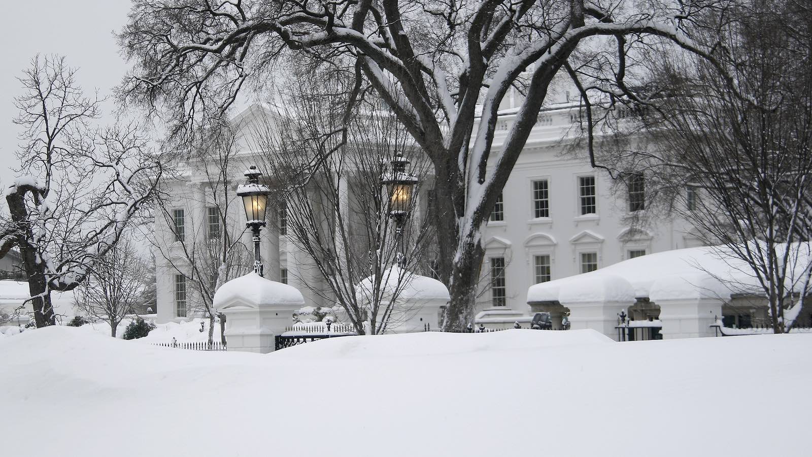
Holiday warmth: During El Niño, late autumn and early winter often bring a period when mild Pacific air gets pushed inland across most of North America as the Pacific jet stream gradually consolidates far offshore. The last El Niño event as strong as this one occurred in 2015-16, and it brought a record-melting holiday “warm wave” to the eastern U.S. Temperatures on Christmas Eve 2015 (December 24) rocketed well into the 60s Fahrenheit across New England, erasing most of the region’s already-scant snow cover. In New York City, Central Park saw its warmest Christmas Eve and Christmas Day in records going all the way back to 1869, with highs of 72°F and 66°F, respectively.
It’s too soon to give a specific forecast for the days around Christmas, but there’s uncommonly strong agreement within the ensemble forecasts of the GFS and European models that an unusually powerful jet stream will take shape above the western North Pacific during the next one to two weeks.
Given the El Niño template at hand — and given the unusually warm waters that now prevail across the mid-latitude North Pacific — there’s good reason to believe that much if not most of the United States and Canada are likely to see unusually mild temperatures for at least a few days before and/or around Christmas, even if the Northeast’s local record highs from 2015 don’t get eclipsed. Relative to the seasonal norm, the most exceptional mildness may occur in Canada.
California rain: After a manna-from-heaven, drought-denting winter across the western U.S., followed by unusual western rains from Hurricane Hilary in August, the Southwest saw an unusually dry autumn.

It’s easy to see why folks from Southern California to New Mexico might be skeptical about the likelihood of El Niño moisture this winter. During the strong 2015-16 event, the western U.S. playbook got turned upside down. Rain and mountain snow were well below average across the Southwest, including much of California, while the Pacific Northwest — where dryness is favored during El Niño — was doused with huge amounts of moisture. In fact, Seattle had its wettest winter on record.
Time will tell about the forthcoming winter, but it’s noteworthy to see a strong North Pacific jet consolidating in the extended forecast models discussed above. Even if the timing and strength are still works in progress, the overall model trends point toward the possibility for a powerful, moisture-bearing Pacific jet slamming into California several weeks from now. Note that a strong El Niño only tilts the odds modestly toward a wetter-than-usual winter across Northern California, and even the more robust relationship in Southern California still isn’t a guarantee, as demonstrated in 2015-16.
East Coast snow: Although winters are generally mild across the Northeast during El Niño, it’s hard to avoid at least one or two cold intrusions. Sometimes these can sync up with the moisture that often swaddles the Southeast during El Niño winters, thus leading to an enhanced chance of a mid-Atlantic snowstorm. Climatology shows that such an El Niño snow is:
- more likely to occur the stronger the event
- most likely to be focused from the central Appalachians to the Delmarva region, as opposed to further north
- most likely to occur during late January and early February (see embedded X/Twitter post below).
The next-strongest El Niño event prior to 2015-16 was 2009-10, and that one was memorably snowy across the mid-Atlantic. The infamous “Snowmageddon” storm on Feb. 5-6, 2010, produced two to three feet of snow and near-blizzard conditions across much of the region, followed days later by another heavy snowstorm. By February 11, the deepest snow cover on record was reported at Dulles and Baltimore-Washington airports, with 26 and 34 inches respectively.
The odds of a snow-favoring East Coast cold wave will be boosted if a sudden stratospheric warming happens to develop in January. Sudden stratospheric warmings involve a rapid and dramatic rise in temperature — as much as 80 degrees Fahrenheit — within the polar stratosphere, together with a disruption in the stratospheric polar vortex. That disruption typically either splits the vortex or pushes it southward, along with associated Arctic air masses. Working in favor of a sudden stratospheric warming is a well-predicted cyclic phenomenon called the quasi-biennial oscillation, involving a switch every 14 to 15 months in wind direction in the tropical stratosphere. This winter, the oscillation is in its easterly mode, which favors sudden stratospheric warming.
On the other hand, low-level air that’s cold enough to support snow may be harder than usual to generate and sustain this winter, given the record warmth that’s prevailed for months throughout the Northern Hemisphere oceans and atmosphere. Several cities along the I-95 corridor from Washington, D.C., to New York made it through the winter of 2022-23 without getting a single inch of calendar-day snowfall, a record-setting absence.
El Niño expert Michelle L’Heureux and Alaska climatologist Brian Brettschneider took stock of the snow prospects this way in a recent deep-dive ENSO Blog post: “El Niño nudges the odds in favor of certain climate outcomes, but never ensures them. There have been some D.C. area snow droughts during past El Niño winters, and climate change is not our friend.”
Looking further out: Odds are rising for a La Niña event (a cooling of the eastern tropical Pacific) to take hold by the latter part of 2024. Cooler-than-average water is gradually expanding beneath the western equatorial Pacific, and seasonal forecast tools such as the North American Multi-Model Ensemble are increasingly leaning toward La Niña by late 2024. Climatology is pointing the same way: Five of the six El Niño events since 1950 that registered as strong in the autumn (meaning an Oceanic Niño Index of at least 1.5 when averaged across the three autumn months, as was the case this year) were followed by La Niña events in the next autumn. Such a sequence would hike the odds of yet another active Atlantic hurricane season.
Jeff Masters contributed to this post. Website visitors can comment on “Eye on the Storm” posts (see comments policy below). Sign up to receive notices of new postings here.
Source link